Tuesday, August 25, 2020

CITY OF BUDA DECLARES STAGE 1 WATER RESTRICTIONS Effective Monday, August 24, 2020

Aug. 20, 2020 - Effective Monday, Aug. 24, 2020, Stage 1 Water Restrictions will go into effect for City of Buda water customers in accordance with the City’s adopted Water Resource Management and Drought Response Ordinance. This is due to the lack of consistent precipitation, and higher than normal demands on our water production system. Under Stage 1, twice per week mandatory watering restrictions are now in place. Violation of the ordinance could result in a fine of up to $2,000 per offense and a surcharge on the customer’s utility bill. For more on Stage 1 restrictions and water conservation tips visit: https://www.ci.buda.tx.us/232/Water-Conservation


Official City of Buda website post: https://www.ci.buda.tx.us/CivicAlerts.aspx?AID=1153
Monday, August 10, 2020

Hays Trinity GCD Declares Drought for Jacob's Well Groundwater Management Zone

Flow at Jacob's Well has dropped below the drought threshold triggering a drought declaration by the Hyas Trinity Groundwater Conservation District at the August 6 Board Meeting. With the Jacob's Well Groundwater Management Zone (GMZ) drought declaration, permittees operating wells within the GMZ are required to reduce pumpage by 20% to extend diminished groundwater supplies. - Wimberley Valley Watershed Association.

Read more here.

 Drought Stage


Note: The Jacob's Well GMZ is in the Hays Trinity GCD boundary and not in the Barton Springs Edwards Aquifer Conservations District boundary.

When It Rains, Texans Forget Drought and Worsening Water Scarcity

 Article by Keith Schneider, Circle of Blue

August 3, 2020

After the Pandemic, soaring population growth, development will again challenge planning and water Supply in the Texas Hill Country.

Monday, August 3, 2020

Tropical Storm Hanna, a Record-Breaking Tropical Storm Season and a Coin-Flip La Nina for the Fall

Summary:
  • The amount of the state under drought conditions increased from about 25 percent four weeks ago to about 36 percent
  • Despite drought conditions, statewide reservoir storage is normal for this time of year
  • Tropical Storm Hanna should improve drought conditions in Central and South-Central Texas
Read full article here


Aquifer Monitoring Tools

No Drought
Lovelady well height: 487 ft-msl
Barton Springs: approximately 61 cfs 10-day avg

Aquifer conditions are dynamic, with water levels often fluctuating 

due to drought, recharge, and pumping. The use of monitor wells 

with specialized equipment helps track these changes in order to 

inform policy that protects water supplies and spring flow for all users. 

After all, groundwater is a shared resource.


We’re often asked the question: 

“How are aquifer conditions determined?” o

“How are aquifers monitored?” 

The short answer: "Monitor wells!" 

You can view the District (and other agency) 

monitor wells and aquifer data HERE.


BSEACD staff employ several types of equipment to collect 

continuous, accurate measurements and observe aquifer 

trends at a number of area monitor wells and for various 

aquifers. Equipment and techniques vary from manual 

periodic measurements with an electric tape, to automated 

sensors that record and store measurements over time.


Many well owners have seen BSEACD staff visit their wells 

to take a manual water-level reading using an e-line. 

A manual measurement is a reliable and accurate method 

to measure water levels in a well and is often used to verify 

automated sensor accuracy. However, a manual measurement 

only represents a snapshot of a well's water level for a given 

date and hydrlogic condition and is time-consuming.

While all monitor wells have manual measurements, wells 

that are only manually measured periodically are called ‘periodic’ 

monitor wells, meaning staff will make a visit one to two 

times a year to get a snapshot measurement.


The most common technique the BSEACD uses to collect 

continuous water levels is equipping monitor wells with a 

pressure transducer probe. The probes measure the 

water pressure above the instrument as it changes and r

ecords the corresponding water level every hour. 

Staff stop by these transducer wells quarterly to 

download the data, or more frequently to aid with scientific studies.


While many continuous monitoring sites are active domestic wells, 

monitoring does not interfere with operation of the well. 

These monitor wells are often plumbed with a small PVC pipe that 

keeps the pressure transducer and cable away from the pump wires 

and the pipe that brings water to the surface.


The newest type of monitoring technology being used for water-level

measurements is a sonic (sound) sensor. This sonic sensor records

the depth to water from the top of the well to the water level using

sound pulses. The data is recorded in real-time and is transmitted via

WiFi to a cloud-based platform which processes and archives the data.

Data can be retrieved at any time with an internet connection.

Staff have deployed seven sonic sensors on Edwards and Trinity

wells in the last two years. One major advantage of this system

is the ability to display water-level readings in real-time through

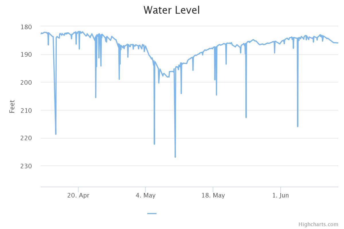
the online dashboard (as seen in the hydrograph below) which helps

to analyze trends over time.


An additional benefit is that the sensor can detect when the pump is 

active and can label the data it collects as under the influence 

of the pump. Several other groundwater entities are now deploying 

these units, including Edwards Aquifer Authority, Comal Trinity GCD, 

and Hays Trinity GCD. This is providing a larger network of real-time 

monitoring.


Water levels are the most basic information one can collect about

groundwater resources. Understanding how water levels are changing

over time in individual wells, and across an aquifer, can tell us a lot

about drought conditions and the increasing demand on groundwater

resources. Therefore, collecting accurate, long-term, frequent, real-time

water-level data is critical to having a science-based approach to 

conservation and management of our most precious shared resource.