Thursday, February 6, 2014

Groundwater Rise Has Ended

No Drought
Barton Springs: 68 cfs 10-day average
Lovelady: 491.04 ft-msl

For the first time since September, water level in the District's Lovelady monitor well is exhibiting a falling trend. The large storms in October provided a sudden and large amount of recharge to the aquifer that dramatically increased the rate of water level which started in September. Just in the last few weeks the rate of rise had begun to flatten out, and finally has reversed altogether. Winter 2013-2014 has seen below average rainfall. Consequently, most creeks over the Edwards aquifer recharge zone have been largely dry and not providing significant recharge.

Thursday, January 30, 2014

Sleet has no Effect on Drought Trigger Sites

No Drought
Barton Springs: 69 cfs (10-day average)
Lovelady monitor well: 491.88

Despite the disruptions it caused in the area, the freezing rain we received this week only amounted to less than 1/10 of an inch according to the District weather station, bringing January's total precipitation to 0.4 inches, well short of the historic monthly average of 2.00 inches. It appears that Lovelady water level may have reached it's peak in the last week after having been on the rise since September of last year and could now be descending, however it is still too early to say for certain.

Below see a hydrograph of Lovelady spanning from the previous peak in water level in the summer of 2012, through the beginning and end of the last drought, and into current conditions.

For real-time hydrograph at Barton Springs click here.
For real-time hydrograph of Lovelady mintor well click here

Thursday, January 23, 2014

Below Average Rain Continues

No Drought
Barton Springs: 69 cfs 10-day average
Lovelady monitor well: 492.21 ft-msl

The dry conditions observed in December are continuing into the new year. As of today, 0.31 inches of rain have been collected at the District rain gauge in January, compared to the historic average of 2.0 inches for the month. Rain is predicted for today and early next week, so there is some chance for conditions to improve. Barton Springs discharge has been steadily decreasing since the big rains in October. At the current rate of decline and without any recharge, drought conditions may be reached as early as Spring.
Lovelady monitor well is reaching a peak in its hydrograph and will likely begin to exhibit a dropping trend in the coming week.
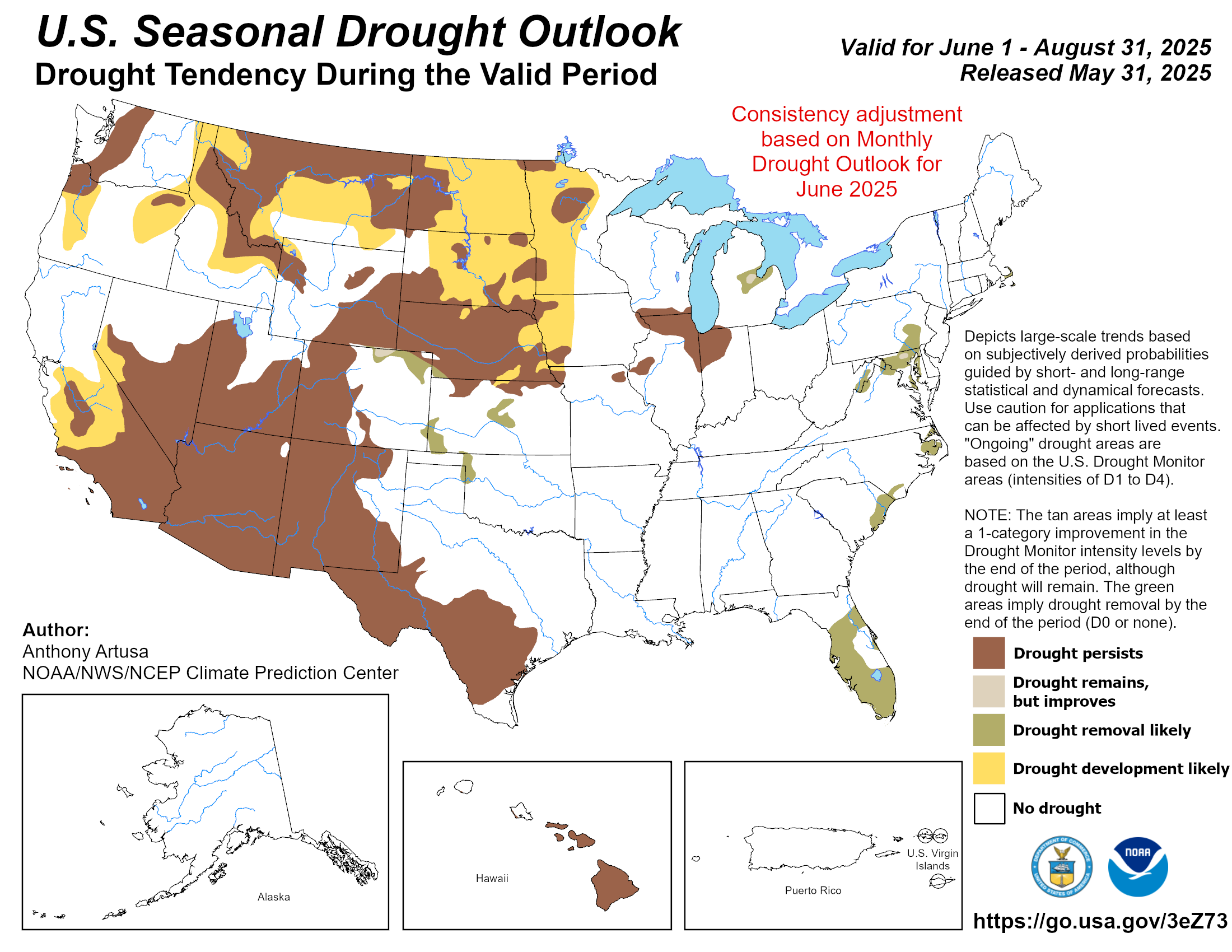
NOAA's seasonal drought outlook predicts that meteorological drought will persist or intensify in the first few months of 2014 in much of central Texas.

NOAA Seasonal Drought Outlook:
http://www.cpc.ncep.noaa.gov/products/expert_assessment/season_drought.png

Below see a hydrograph of Lovelady well through the last few drought cycles.

Thursday, January 9, 2014

Groundwater Rise Slowing

No Drought
Barton Springs: approximately 73 cfs
Lovelady monitor well: 491.6 ft-msl

2013 ended on a dry note. In December the district rain gauge received 0.71 inches of rain, compared to the historic average of 2.5 inches. Despite dry conditions, the Lovelady monitor well hydrograph continues to rise after above-average rainfall in September and the big storms in October generated prolonged recharge to the aquifer, but is starting to slow its rate of rise. The District is currently out of drought, unlike the agencies in the surrounding area. It is important to use water resources conservatively, even in times of no drought given the fickle nature of rainfall in central Texas and the unknown long-term climate trends going into the future.

Thursday, December 26, 2013

Aquifer Update

Status: No Drought
Barton Springs: 75 cfs, very slow decline
Lovelady: 489 ft-msl and rising

On December 21 we had up to about 1 inch of rainfall that helped creeks increase in flows and result in some increased recharge. Although streams are quickly declining, the rainfall has helped to sustain the creek flow and recharge that we've enjoyed since September.

Our good aquifer levels are a bit unusual for the region. Other water resources have not benefited from the wet September and October like the Barton Springs segment of the Edwards Aquifer. For example, to our south the San Antonio segment of the Edwards Aquifer is in Stage 3 drought declaration. The highland lakes are only at ~38% capacity, and so Austin and the region depending on surface water are also under drought restrictions. West of the District, in Hays County, the Hays-Trinity GCD is under Alarm drought conditions. We have to be mindful that we can join drought status like these other agencies in a matter of months if dry conditions come back to our area. Let's hope the wet trend continues into the New Year.


Tuesday, December 10, 2013

Water Levels Continue to Rise

No Drought
Lovelady monitor well: 486.01 ft-msl
Barton Springs: Approx. 77 cfs 10-day average. 

Aquifer water levels continue to rise. The water level in the Lovelady monitor well has risen 10 feet in the last month. District staff are monitoring conditions closely. Below see an up-to-date hydrograph of Lovelady monitor well. 

Wednesday, December 4, 2013

Aquifer Levels Still Rising

Drought Status: Non-Drought
Lovelady Monitor Well: 484.78 ft-msl
Barton Springs: approx. 100 cfs 10-day average

Water level in the District's monitor well continues to rise after the storms in October brought record rains and flooding and good rainfall continued into November. Many of the major creeks, where the majority of recharge to the aquifer occurs, have experienced prolonged flow. According to the District rain gauge, rainfall in November reached 2.57 inches, just above the historic average of 2.5 inches.

Friday, November 22, 2013

Non-drought conditions declared Tuesday Nov. 19, 2013

Drought Status: No Drought (declared Tuesday November 19, 2013)
Barton Springs: ~89 cfs (10-day average)
Lovelady: 480.2 ft-msl (appears to be leveling off)
From the press release:
The Barton Springs/Edwards Aquifer Conservation District’s General Manager has declared a No-Drought condition for the aquifers within the District, effective immediately. The declaration comes after a wet September that saturated soils, then record-setting rainfall in October that caused runoff to area creeks which swelled beyond their banks allowing substantial recharge to the aquifer. One of the area’s two groundwater drought indicators, the water level in the Lovelady Monitor Well, has been rising steadily since the storms in mid- and late-October. On Sunday, November 17, the water level in the Lovelady Well crossed above the District’s drought threshold, a rise of over 19 feet in about a month. The other drought indicator, sustained flow rate at Barton Springs, moved above its threshold after the precipitation events in mid-October and has remained there.  Both indicators need to be above their designated thresholds – and currently are – to emerge from drought.
The District declared a groundwater drought and has been enforcing mandatory water-use restrictions since November 15, 2012, just over a year ago. While the aquifer has received substantial recharge and has passed into No-Drought status, it is still below average water storage capacity.  “The water level at the Lovelady well is still 22 feet below average, but the rapid recharge caused by the recent storms has greatly improved groundwater conditions around the District,” said Robin Gary, Public Information Coordinator.  Groundwater users are encouraged to maintain conservation practices, but mandatory water use restrictions are lifted. 
Brian Smith, Aquifer Science Team Leader, stated that, “These exceptional rain events in October fell over parts of the Edwards Aquifer recharge and contributing zone, but the western parts of the contributing zone received only moderate amounts of rain, so we are not likely to see flow continuing in the creeks for an extended period of time.  Without significant rain this fall and winter the aquifer could return to drought status by late winter or spring.”
The District’s General Manager, John Dupnik, offered this reminder stating that, “Despite the exceedingly wet conditions this fall, it is important that groundwater users not forget about the preceding summer months during which severe to extreme meteorological drought gripped the area, and as a consequence, caused water levels in the aquifer to plummet to close to Stage IV Exceptional Drought conditions.” Even in No-Drought status, end users are encouraged to continue to conserve.  Conserving water can prolong the time spent out of groundwater drought and protect water levels and springflow at Barton Springs.

Thursday, November 14, 2013

Aquifer on verge of non-drought conditions

Drought Status: Alarm Stage II
Lovelady: 476.23 ft (and rising)
Barton Springs: 86 cfs (89 cfs 10-day average)*
*based on manual measurements and estimates

The Drought Status is on the agenda at tonight's Board meeting. Barton Springs is already above its drought indicator thresholds, and it is only a matter of days before the Lovelady well is similarly above its thresholds. Board members could elect to declare non-drought conditions in the near future.


Tuesday, November 12, 2013

November Aquifer Update

Drought Status: Alarm Stage II (but likely will exit drought in the next week); the drought status can only be changed by the direction of the Board of Directors.

Lovelady: 475.76 ft-msl (and rising about 0.5 ft/d)
Barton Springs: Data still unavailable from the USGS, but manual measurements we've made recently put it near 60 cfs.

Synopsis: The wet September and the two rain bombs we received in October (wettest October ever at Camp Mabry!) has brought the Aquifer out of Stage III and into Stage II (Board changed on 10/24/13). The substantial recharge from these rains provided enough moisture to provide sustained creek and river flows in the area--thus providing sustained recharge. For example, Onion Creek is flowing nearly 80 cfs today, nearly all of that becomes recharge. Thus, we expect both our drought indicators (Lovelady and Barton Springs) to be above their respective drought thresholds by early next week). The Board meets this Thursday (11/14/13) and could take action given the rising trends.

A good summary of the impact of recent rains can be found in our latest newsletter: HERE