The Electro Purification (EP) aquifer test began in October and will likely finish in the coming weeks. EP contractors, District staff, and the Edwards Aquifer Authority (EAA) staff are coordinating testing activities and monitoring efforts. Aquifer tests are an essential part of the District's permitting process. The Board and staff rely heavily on results of these tests to inform permit volumes and conditions.
Synopsis of aquifer test activities:
EP converted the Odell 1 well into a Lower Glen Rose monitor well. They have developed and pumped Bridges 2 and Bridges 1 for 5 and 7 days, respectively. Most recently, Odell 2 was developed and tested for 5 days. During development of Odell 2, EP contractors experienced technical difficulties that delayed the start of the test; however, the pump phase is complete and water level recovery is being recorded. During all tests, water level and water quality data were collected. Provisional District water-level data from the deep Cow Creek monitor wells show a measurable response to the pumping. The measurable response is what is needed to allow calculations of aquifer parameters such as transmissivity and storage.
Currently, the EP contractors requested and received approval to re-test Bridges 2. After the test was complete, the EP contractors discovered that the original pump assembly installation was not placed properly. The well will not be developed again, but crews will reinstall the pump assembly and begin pumping in the upcoming weeks. Water levels are continuously being recorded.
What happens next:
Once the testing is complete and water levels have recovered, both the District staff and EP contractors will compile and check all data collected over the duration of the aquifer test. Once compiled, organized, and checked, the District will share data with surrounding GCDs and EP contractors. EP contractors will go through the same process. After all data is available, EP contractors will analyze the data and propose a permit volume based on those analyses, explained through their Hydrogeologic Report. The Hydrogeological Report is required with submittal of a production permit application to support a requested permit volume. When a production permit application is submitted by EP to the District, District staff will review and vet the contractor's Hydrogeologic Report, model effects of the requested volume, and determine whether the requested volume may have potential to cause unreasonable impacts to surrounding wells. The staff's findings will be presented to the Board to inform the permit desision.
To make the aquifer test more transparent to the groundwater community, the District (with EP's support) posts updates on the EP Aquifer Test Spotlight page.
|
Thursday, March 2, 2017
EP Aquifer Test Activities and Timeline


Barton Springs Hackathon
The Barton Springs Hackathon is a one-day, hands-on, technical workshop focused on unlocking hydrologic data in central Texas for public consumption. The District has teamed up with the Texas Advanced Computing Center to host the first Barton Springs Hackathon! With support from the Hill Country Alliance, the Hackathon will be a fun day to learn, teach, and help make data more accessible.

Here’s where you can help – we need everybody from coders to scientists to educators that can unlock the information collected from a large network of monitoring sites and help well owners and central Texas residents understand the groundwater system that feeds Barton Springs. Join a project team and lend your expertise to the challenge!
Read more here!
Thursday, December 8, 2016
2016 Edwards Aquifer Status In Review
Lovelady well height: 542.25 ft-msl (11.44 ft-Depth to Water)
Barton Springs: approximately 109 cfs 10-day average
2016 began in a status
of No Drought following a very wet 2015 summer and. Those summer and rains augmented a
trend which initiated back in September 2014, when water levels began to rise
after above-average rainfall. Steady recharge continued to increase aquifer water
levels, as well as Barton Springs flow. In January of 2015, the Board updated
the drought status from Stage II Alarm Drought to No Drought. This change has
remained in effect throughout 2016, as Edwards water levels have continued to
rise. To note, recent measurements indicate the beginning of a decline starting
October 11th.
An overall wet 2016
produced long periods of recharge, resulting in the second highest water level
elevation for the District’s Edwards Aquifer drought index well, the Lovelady
Monitor Well. Water levels peaked on October 5, 2016 at 545.8 ft-msl, second to
the 547.2 ft-msl recorded on June 2,1992. The Lovelady Monitor Well has
recorded data since 1949.
Almost mirroring the rejuvenating effects of
2015, periods of heavy rainfall in 2016 have continued to boost the Edwards
Aquifer. For close comparison total rainfall for 2015, measured at Camp Mabry,
was 59”, and 2016 is coming in at a close 55”

Thursday, October 27, 2016
Hill Country Alliance's 7th Annual Rainwater Revival!
Come join BSEACD and many others for the Hill Country Alliance's 2016 Rainwater Revival event November 5th (Saturday) at the Dripping Springs Ranch Park from 10 am to 4 pm in Dripping Springs. The day will be full of fun, education and celebration!
As we all know, water is scarce in the Texas Hill Country. With our drought-and-flood climate and stressed water supply, alternatives to traditional water project development can help increase reliability, conserve resources and protect the environment. An effective, desirable and responsible alternative is rainwater harvesting.
Now in its 7th year, the Rainwater Revival brings together homeowners, builders, vendors and conservation experts to connect, share and celebrate the ancient tradition of harvesting rainwater.
For more information visit here.
EP Aquifer Test Approved
Aquifer tests are an essential part of the District's permitting process. The Board and staff rely heavily on results of these tests to inform permit volumes and conditions.
In the spring, Electro Purification (EP) submitted a test well application to allow them to perform an aquifer test on three wells. District staff worked with EP to design and plan an aquifer test that meets District guidelines. The aquifer test will measure responses to abbreviated pumping simulations from the target pumping zone (Middle Trinity--Cow Creek Formation) in surrounding Upper, Middle, and Lower Trinity wells (generalized stratigraphic column showing aquifers and associated formations). The aquifer test is a collaborative effort between the District and EP and will take two to three months to complete.
Synopsis of aquifer test activities:
EP contractors will convert the Odell 1 well into a Lower Glen Rose monitor well. They will plug the bottom portion of the well to seal off the Cow Creek formation, so water level monitoring in the Middle Trinity above the target pumping zone can be monitored. Then EP contractors will develop and install temporary well completions in the three test wells that allow pumping to be isolated to the target pumping zone. They will develop and test Bridges 1 then move to Bridges 2, then Odell 2. During the development and testing, EP contractors and District staff will be sampling water quality and water levels. EP contractors are responsible for monitoring/sampling wells on EP leases. District staff are coordinating with surrounding well owners to monitor/sample additional monitor well sites. As agreed with EP, District staff will be at the well site to observe key well development and testing activities.
In anticipation of community interest and information requests and to make the aquifer test more transparent to the groundwater community, the District (with EP's support) has created a Permit Notice: EP Aquifer Test web page with the following the following information:
|
Monday, September 26, 2016
Fall Has Arrived! La Niña too?
Lovelady well height: 545.51 ft-msl (107.91 ft- Depth to Water)
Barton Springs: approxamately 113 cfs 10-day average
Fall 2016 has arrived and hopefully it will
soon bring with it some much-desired cooler temperatures. However, one thing it
may not be bringing is a La Nina. What will that mean for the coming
fall and winter?
We’re all well-familiar with El Niño
after an extremely strong occurrence of the phenomenon brought unusually high
rainfall totals throughout the spring and summer of this year (48.3 inches thus
far in 2106).El Niño occurs when there are unusually high sea surface
temperatures in the Pacific. Conversely, La Niña happens when there are
unusually low sea surface temperatures. In Central Texas, El Niño brings
unusually high rainfall in spring and summer, while La Niña brings rainfall in
the fall and winter. For more information on both La Niña and El Niño, take a
look at this page created by the Pacific Marine Environmental
Library, part of NOAA.
Although surface water temperatures in the
Pacific have been cooling since the peaks of El Niño, they are not decreasing
at the rate climatologists had previously predicted. According to Reuters,
U.S. government forecasters have decreased their prediction of a La Niña
occurring from a probability of 76 percent (put forth in May) to just 36
percent. This month, NOAA officially dropped its “La Niña Watch,” in place
since April.
All
indicators are pointing to a no-Niña winter. That likely means it will also be
a dry one. Regardless, fall greetings to all from BSEACD.
Wednesday, September 14, 2016
2016 Hyro Geo Workshop! (Sept. 30th - Oct. 2nd)
Come spend the weekend with BSEACD, the Edwards Aquifer Authority and many others in real-world field settings, gaining valuable hands-on experience at the 2016 Hydro Geo Workshop September 30th through October 2nd.
The Texas Hydro-Geo Workshop is centered on the collection, processing, analysis and evaluation of hydrologic and geologic field data. It serves as an excellent introduction for aspiring geology, hydrology, and environmental science students, as well as a refresher for seasoned professionals.
The Workshop was created to bring students and professionals together in a field setting for a hands-on learning experience. This is a special opportunity to work with leading researchers and practitioners from across the state and nation. Participants have the opportunity to explore many different techniques for collecting data from soil, rock, and water media. This includes drilling rigs, surface and borehole geophysics, stream gauging, water quality instruments and more.
Participants can select from the various modules depending upon availability. Please note that participation may be limited in some modules for safety reasons, to maintain a high participant/coordinator ratio, or for resource protection.
The Workshop will take place at and around Cave Without a Name near Boerne, Texas. Most activities will be centered at the campsite and pavilion.
Register here soon as there are only about 100 tickets left!
Registration is $60.00 and ends Sept. 30th.
Friday, September 2, 2016
September 6th, National Protect Your Groundwater Day!
Lovelady well height: 544.45 ft-msl (108.97 ft- Depth to Water)
Barton Springs: approxamately 114 cfs 10-day average
The National
Groundwater Association's National Protect Your Groundwater Day helps focus
attention on how important groundwater is as a shared resource and encourages
everyone to do their part to help protect groundwater resources. The
District agrees!
Everyone can and should do something to
protect groundwater. Why? We all have a stake in maintaining its quality and
quantity. Here are a few statistics and details from the National
Groundwater Association...
- For starters, 99 percent of all available freshwater comes from aquifers underground. Being a good steward of groundwater just makes sense.
- Not only that, most surface water bodies are connected to groundwater so how you impact groundwater matters.
- Furthermore, many public water systems draw all or part of their supply from groundwater, so protecting the resource protects the public water supply and impacts treatment costs.
- If you own a well to provide water for your family, farm, or business, groundwater protection is doubly important. As a well owner, you are the manager of your own water system. Protecting groundwater will help reduce risks to your water supply.
For more information about local
groundwater resources, tips and tricks for well maintenance, water quality
information, treatment options, and other well owner resources, check out the District's
Well Owner Guide.
Monday, August 8, 2016
Edwards & Trinity Water Levels Declining
Lovelady well height: 542.87 ft-msl (110.55 ft-Depth to Water)
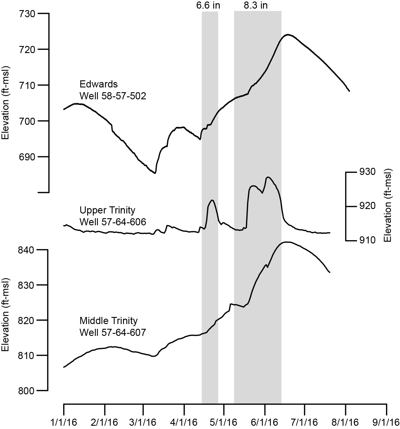
Barton Springs: approximately 109 cfs 10-day averageCentral Texas enters August with none of the area in drought conditions. This is directly the result of the wet winter and spring of 2015-2016 leading to some near-historic rainfall totals and high surface-water and groundwater levels. Groundwater levels in the Edwards and Trinity Aquifers reached their peak elevations in mid-June, and are now declining with the lack of rain in much of central Texas. The figure illustrates the rise and fall of aquifer levels in three wells in central Hays County for 2016.
Friday, July 1, 2016
Study: Surface and Groundwater Interactions in Onion Creek and Blanco River
Lovelady well height: 541.50 ft-msl (113.74 ft-Depth to Water)
Barton Springs: approximately 114 cfs 10-day average

The Edwards and Trinity Aquifers provide critical water resources to Central Texas. Streams that create the beautiful Texas Hill Country are in fact hydrologically linked to the aquifer (groundwater) systems. Aquifers provide springflows that sustain the streams, and the streams, in turn, recharge the aquifers.
Many studies, going back
decades, document the surface and groundwater interactions in the Edwards
Aquifer. However, despite the growing demand for water and increasing threats
to surface water resource from both ecological and human health perspectives,
few studies have been conducted to understand those interactions in the Hill
Country Trinity Aquifers of Central Texas. The purpose of this document is to
summarize new information from recent studies along the Blanco River (Smith et
al., 2015) and Onion Creek (Hunt et al., in press). These studies provide a
greater understanding of the surface water and groundwater resources in the
area that could help guide policies for groundwater and surface-water
management, and also guide future scientific studies.
Both studies used
similar methods that included measuring losses and gains of stream flow to
identify recharge and springflow areas. Other methods used included measuring
water levels from wells and water chemistry. Results from these studies have
common conclusions for both the Blanco River and Onion Creek, including:
- Complex surface and groundwater
interactions with alternating gaining
and losing reaches present during both high and low creek-flow conditions.
Gaining reaches are due to the presence of springs and spring-fed tributaries
that increase flows in the streams, while losing reaches result from
recharge features (sinkholes, fractures, and caves) that drain water from
the stream into the aquifer;
- Losing portions of the streams
provide recharge to the Upper and Middle Trinity Aquifers; and,
- Gaining portions of the streams
over the Trinity Aquifers provide for recharge downstream to the losing
reaches over the Edwards Aquifer,
which provide base flow to Barton and San Marcos Springs.
In summary, these
studies provide strong evidence that water flowing in the Blanco River and
Onion Creek are recharging the Trinity and Edwards Aquifers along certain
reaches of the streams. The greatest uncertainty of these studies is how much,
how quickly, and under what conditions does recharge occur into the Trinity
Aquifer.
To address these
uncertainties scientists are continuing to collect hydrogeologic data and
planning additional studies. Future studies could involve dye tracing to
determine the fate of the surface water after it enters the aquifer, additional
flow measurements, more extensive water-level measurements, and further
geochemical analyses of groundwater and surface water.
References
Hunt., B.B., A.S.
Broun, D.A. Wierman, D.A. Johns, and B.A. Smith, In Press, Surface and
Groundwater Interaction Along Onion Creek, Central Texas: Gulf Coast
Association of Geological Societies Transactions, 66th Annual Convention,
September 18-20, 2016, Corpus Christi, Texas.
Smith, B.A., B.B.
Hunt, A.G. Andrews, J.A. Watson, M.O. Gary, D.A. Wierman, and A.S. Broun, 2015,
Hydrologic Influences of the Blanco River on the Trinity and Edwards Aquifers,
Central Texas, USA, in Hydrogeological and Environmental Investigations in
Karst Systems, (Eds) B. Andreo, F. Carrasco, J. Duran, P. Jimenez, and J. LaMoreaux,
Environmental Earth Sciences, Springer Berlin Heidelberg, Volume 1, pp 153-161.
Acknowledgements
This research would
not be possible without collaboration with the Hays Trinity Groundwater
Conservation District, City of Austin, Edwards Aquifer Authority, local
scientists, and land owners.
Subscribe to:
Posts (Atom)

