No Drought
Lovelady well height: 528 ft-msl (126 ft- Depth to Water)
Barton Springs: approximately: 113 cfs 10-day average
Monday, March 18:
Sample bags available for pickup at District office*. Can be picked up anytime from March 18 - April 16.
Tuesday, April 16 - After hours drop-off begins after 5pm:
Last day to register and pick up supplies. After hours sample drop-off available at the District office after 5:00pm. Samples must be less than 24 hours old.*
Wednesday, April 17 - Samples must be received by 2pm:
Day to drop off samples, which must be less than 24 hours old. Well Water samples will be screened in-house for nitrate, pH, and salinity (TDS). Bacteria will be processed by an off-site lab. Preliminary results available after a short wait.
*District office is located near 1626 and Manchaca Rd. in far south Austin. Address is: BSEACD, 1124 Regal Row, Austin, Texas, 78748. Office hours: 9:00 - 5:0pm. After hours sample drop-off will be available after 5:00pm, Tuesday, April. 16, 2019. Samples can be dropped off but must be less than 24 hours old and results will be mailed.
Visit HERE for more info and video instructions on how to take a water sample!
Tuesday, March 19, 2019
Monday, March 4, 2019
Proposed Kinder Morgan Pipeline
No Drought
Lovelady well height: 526 ft-msl (127 ft- Depth to Water)
Barton Springs: approximately: 123 cfs 10-day average
Kinder Morgan has proposed a natural gas pipeline that crosses through the Barton Springs/Edwards Aquifer Conservation District (District) in Hays County. The Proposed alignment crosses environmentally sensitive areas. Staff have compiled data in the form of maps to examine how the proposed alignment is related to the hydrogeology of the District. See maps and more info here.
Lovelady well height: 526 ft-msl (127 ft- Depth to Water)
Barton Springs: approximately: 123 cfs 10-day average
Kinder Morgan has proposed a natural gas pipeline that crosses through the Barton Springs/Edwards Aquifer Conservation District (District) in Hays County. The Proposed alignment crosses environmentally sensitive areas. Staff have compiled data in the form of maps to examine how the proposed alignment is related to the hydrogeology of the District. See maps and more info here.
Monday, February 11, 2019
Austin Cave Festival 2019!
No Drought
Lovelady well height: 522 ft-msl (131 ft- Depth to Water)
Barton Springs: approximately: 112 cfs 10-day average
Austin Cave Festival
Saturday, Feb. 23, 2019 (10am - 3pm)
Lady Bird Johnson Wildflower Center
4801 La Crosse Ave., Austin, TX 78739
Come join the BSEACD for this free, family-friendly event featuring hands-on activities, cave tours, live music, and more. Visitors will have the opportunity to explore a cave and see how water makes its way to the aquifer and Barton Springs, learn about animals that call Austin's caves home, try on cave gear, and learn how to protect and conserve Austin's water resources. Click here for more info

Lovelady well height: 522 ft-msl (131 ft- Depth to Water)
Barton Springs: approximately: 112 cfs 10-day average
Austin Cave Festival
Saturday, Feb. 23, 2019 (10am - 3pm)
Lady Bird Johnson Wildflower Center
4801 La Crosse Ave., Austin, TX 78739
Come join the BSEACD for this free, family-friendly event featuring hands-on activities, cave tours, live music, and more. Visitors will have the opportunity to explore a cave and see how water makes its way to the aquifer and Barton Springs, learn about animals that call Austin's caves home, try on cave gear, and learn how to protect and conserve Austin's water resources. Click here for more info

Wednesday, January 16, 2019
January 2019 Recharge in Action
No Drought
Lovelady well height: 514 ft-msl (139 ft-Depth to Water)
This wet period has produced a prolonged period
of streamflow throughout the region. Often the streams in the Hill Country are either
dry or have very low flow. The rains are sustaining stream flow in creeks and
rivers that are providing substantial recharge to the Trinity and Edwards aquifers.
In addition, much of Central Texas is a karst landscape, meaning a large fraction of the rainfall we receive infiltrates through soils or direct flow into recharge features such as caves or sinkholes.
So, groundwater resources are presently
experiencing high levels of recharge and high water levels and springflow such
as Barton Springs (Edwards Aquifer) and Jacob’s Well (Trinity Aquifer), both
flowing higher-than average.
These wet conditions, flowing streams, and increased recharge will allow us to avoid entering severe drought conditions for months to come. As always, despite these good conditions, we always encourage everyone to be mindful of water use and practice conservation. We know in Texas hydrologic conditions can change rapidly, such as the flash drought of 2011 demonstrated.
Lovelady well height: 514 ft-msl (139 ft-Depth to Water)
Barton Springs: approximately 106 cfs 10-day average
Austin and Central Texas entered the new year
following some of the wettest December weather ever recorded. On Friday, Dec.
7, 2018, ABIA recorded 3.5 inches of rainfall, over six times greater than the previous
December record for a day. In fact, the precipitation recorded that day
alone was more than the average rainfall for the entire month (2.2 inches). By New Year’s Eve, 6.0 inches of rain had
fallen in Austin and the Hill Country for the month of December which is more than two times the average.
The wet trend continued into early January 2019
with the Austin area totaling about 3.0 inches, exceeding the historical
average of 1.9 inches for the month of January. This record rainfall has
resulted in substantial recharge, thus the BSEACD, like most of the State, are
not experiencing drought conditions.
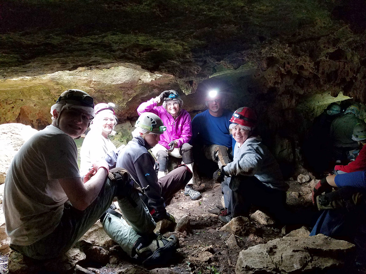
| IMAGE 1: Inside View of Cave Receiving Recharge |
In addition, much of Central Texas is a karst landscape, meaning a large fraction of the rainfall we receive infiltrates through soils or direct flow into recharge features such as caves or sinkholes.
| IMAGE 2: Cave Taking Recharge in Driftwood |
These wet conditions, flowing streams, and increased recharge will allow us to avoid entering severe drought conditions for months to come. As always, despite these good conditions, we always encourage everyone to be mindful of water use and practice conservation. We know in Texas hydrologic conditions can change rapidly, such as the flash drought of 2011 demonstrated.
Friday, December 14, 2018
2018 Aquifer Status Recap
No Drought (Board declared on 10/11/18)
Lovelady well height: 504 ft-msl (150 ft-Depth to Water)
Barton Springs: approximately 97 cfs 10-day average
Lovelady well height: 504 ft-msl (150 ft-Depth to Water)
Barton Springs: approximately 97 cfs 10-day average
2018 began with a status of No Drought, following a trend which began back in September 2014, when water levels began to rise after above-average rainfall. Steady recharge throughout 2015 and 2016 continued to increase aquifer water levels as well as Barton Springs flow. In January 2015, the Board updated the drought status from Stage II Alarm Drought to No Drought. After two consecutive years of average rainfall in 2017 and 2018, water levels and Barton Springs flow fell below their respective Drought thresholds. On July 12th, 2018, the District Board declared Stage II Alarm Drought, ending a 3-year and 6-month No Drought status.
Measurements began to decline in April 2017 and eventually crossed below drought warning levels in July 2018. Then an average of 12 inches of rain in September and October 2018 produced much needed recharge, resulting in rising aquifer levels. They rose above the Stage II Alarm Drought threshold in early October and the Board declared No-Drought at the October 11th, 2018, Board Meeting.
Austin has received and overall 32” of rainfall as of December 14th 2018, producing significant recharge for local aquifers. While levels continue to climb from additional rainfall, much more recharge is needed to bolster against another decline a the the Lovelady Monitor Well.
Official forecasts favor the formation of a weak El NiƱo in the Pacific, which is likely to result in wet conditions through the winter and into Spring 2019.
Happy Holidays and a Happy New Year from the BSEACD!
Tuesday, October 23, 2018
Groundwater User Water Quality Concerns Due to Recent Rains
No Drought (Board declared on 10/11/18)
Lovelady well height: 485.9 ft-msl (167.5 ft-Depth to Water)
Barton Springs: approximately 73 cfs 10-day average
Lovelady well height: 485.9 ft-msl (167.5 ft-Depth to Water)
Barton Springs: approximately 73 cfs 10-day average
Flooding in the highland lakes region has caused the City of Austin to issue a boil water and emergency conservation notice for Austin Water customers on Oct. 22, 2018. Several groundwater users have contacted the District to ask if they should be concerned about groundwater water quality. There is no indication that regional groundwater quality has been negatively impacted by the recent rain events. The major floods have been outside the District’s recharge and contributing zones; however, well owners should pay close attention to any changes in their well water.
During rain events, wells in karst aquifers (like the Edwards & Trinity Aquifers) can see quick recharge, just as the Highland Lakes have seen. Runoff can wash sediments and contaminants into the groundwater system. Occasionally, well owners notice a change in taste, odor or appearance after rains—this is an indicator that the well is directly connected to the surface through caves or fractures common in karst aquifers. If groundwater users ever notice a change in taste, odor or appearance, you can boil the water before drinking or use bottled water to be cautious. If you have a question about your water quality, you can take a sample to an area lab to have it analyzed. Common treatment systems that take care of bacteria (the most common surface contaminant) use either chlorination, ultraviolet light, or reverse osmosis for their drinking water.
The silt, sediment, and other particulates in the Colorado River are so high that surface water systems’ filters and treatment equipment are having trouble keeping up with demand. While Edwards and Trinity Aquifer wells are not tapped into the Colorado River, those same recent rain events may have washed surface sediments and contaminants into the groundwater.
There’s a good overview of wells and major rainfall events here: https://bseacd.org/2015/11/wells-and-major-rainfall-events/
Monday, October 15, 2018
Aquifer District Lifts Drought Declaration
No Drought (Board declared on 10/11/18)
Lovelady well height: 482.4 ft-msl (171.0 ft-Depth to Water)
Barton Springs: approximately 75 cfs 10-day average
Lovelady well height: 482.4 ft-msl (171.0 ft-Depth to Water)
Barton Springs: approximately 75 cfs 10-day average
At
the October 11 Board Meeting, the Barton Springs/Edwards Aquifer Conservation
District’s Directors declared a No-Drought condition for the aquifers within
the District, effective immediately. While rainfall totals across central Texas
varied significantly in September and October, areas in the contributing and
recharge zones received enough rain to saturate soils and allow runoff to
generate stream flow in the recharge zone creeks. One of the area’s two
groundwater drought indicators, Barton Springs discharge, has been above the
Stage II Alarm Drought threshold (10-day average of 38 cubic feet per second)
since September 9, 2018. On Friday, October 5, 2018 the water level in
the Lovelady Well crossed above its drought threshold (478.4 feet above mean
sea level). Both indicators need to be above their designated thresholds – and
currently are – to emerge from drought.
The
District declared a groundwater drought and has been enforcing mandatory
water-use restrictions since July 2018. Sustained creekflow in the
recharge zone creeks has generated substantial recharge to the aquifer.
Water levels are still below average, but with additional rainfall they could
continue to rise. Groundwater users are encouraged to maintain
conservation practices, but mandatory pumping curtailments are lifted.
Useful
links:
- Drought Status page: http://bseacd.org/aquifer-science/drought-status/
- Press Release
archive: http://bseacd.org/publications/press-releases/
- Drought Management
page: http://bseacd.org/regulatory/drought-management/
- Water Conservation &
Protection page: http://bseacd.org/education/water-conservation/
Monday, September 24, 2018
Drought in the Barton Springs segment of the Edwards Aquifer: Are we in or out?
Alarm Stage II Drought
Lovelady well height: 475 ft-msl
Barton Springs: approximately 90+ cfs 10-day average (USGS gauge is currently under maintenance)
Lovelady well height: 475 ft-msl
Barton Springs: approximately 90+ cfs 10-day average (USGS gauge is currently under maintenance)
September 23, 2018
Since early September we’ve received more than 10 inches of
rainfall that has ultimately produced runoff and recharge to the aquifer.
Present the streams are flowing (Onion Creek > 100cfs), water levels are
rising, and Barton Springs is flowing > 60 cfs). So how can we still be in
drought?
In fact, I received a call late last week from a groundwater
user pointing out that the local news declared the end of the drought last week,
and they asked why is it that the BSEACD is still under official Stage II Alarm
drought declarations since July 12th. Indeed, for our area the US drought monitor
maps show drought conditions in early September and then non-drought conditions
by mid-September after the rains (https://droughtmonitor.unl.edu/).
The primary reason is that changes in the amount of
groundwater in an aquifers generally lag behind the effects of weather for a
variety of reasons. Drought is defined as “a period of drier-than-normal
conditions that result in water-related problems.” However, there are several varieties
of drought, with what most people consider drought actually classified as a meteorological
drought—a rainfall deficit effecting the landscape. However, over time the lack
of rain produces agricultural and ultimately hydrological droughts. Droughts
that affect the Barton Springs segment of the Aquifer can be best characterized
as hydrological, but more specifically a groundwater drought.
Groundwater droughts, by the very nature of the hydrologic
cycle, often have a time-lag response to high rainfall, or lack of rainfall,
conditions. The District utilizes flow from Barton Springs and water levels in
the Lovelady monitor well to indicate overall storage and drought status of the
aquifer. Barton Springs is the primary natural discharge point and is a good
measure of the overall health of the aquifer system. However, like a stream,
but Barton Springs can be highly sensitive to relatively minor and localized rainfall
events. We’re seeing this right now with Barton Springs responding to these
rains and flow well above its drought trigger. Conversely, the Lovelady well has
a muted response to minor rainfall, but is a good measure of overall storage in
the aquifer. Water levels have responded to the drought and are rising, but are
below their trigger level for now.
For the District to declare drought conditions either spring flow or the Lovelady water levels need to be below their respective drought
thresholds. However, to exit a drought stage, both spring flow and water level must rise above their respective
drought trigger values. This latter requirement keeps the District from making
multiple declarations about drought over short periods of time. A good example
occurred in 2014 when the District officially remained in Alarm Drought Stage
II from July 2014 through January 2015 (Figure
1). However, during that period Barton Springs temporarily responded to two
large rain events that did not result in significant increases in recharge and storage
to the aquifer as indicated by water levels in the Lovelady well.
The good news about the current groundwater drought is that
the Lovelady water-level trends are currently rising upward at a rate of about
(0.3 ft/day) and if they continue rising, we may be out of drought by early October 2018. The short-term
and long-term forecasts are calling for more rain, so the outlook is very good
that we may exit groundwater drought conditions soon.
More information on District’s drought trigger methodologies:
Figure 1. Period of Stage II Alarm Drought from 2014. The
BSEACD declared drought in July 2014 and then exited drought conditions in
early 2015. This illustrates that Barton Springs responded to rainfall events,
but did not result in significant increases in storage within the aquifer as
represented by the Lovelady Well.
Friday, September 14, 2018
Fall Rain Fall!
Alarm Stage II Drought
Lovelady well height: 472 ft-msl
Barton Springs: approximately 43 cfs 10-day average
The wet weather pattern continues around Austin!
Today (9/14) marks our 12th day in a row of rain in the region, and it looks like we have five or so more to go. According to Spectrum News, there’s a pretty good chance for rain from the system developing in the Gulf of Mexico. NOAA currently predicts a 60% chance it’ll become a Tropical Depression in the next 48 hours and it might even grow to Tropical Storm Joyce.
Given how saturated the ground has become, it won’t take much rain to cause flash flooding in the area. So be aware, Turn Around, Don't Drown.
Spectrum News’ computer models points to a landfall somewhere along the Lower or Middle Texas Coast by Friday evening, with rain spreading all the way up across Central Texas in Saturday. That said, there’s still a lot of uncertainty with this forecast.
So what do es this mean for our current drought conditions?
The BSEACD drought outlook valid from August 30, 2018, to September 13, 2018 remains in “ALARM STAGE II Drought”. Even with the recent rains in the Hill Country and Austin averaging 7”(LCRA) raising Barton Springs flow, aquifer levels remain below Stage II trigger levels. Much needed recharge certainly occurred and area creeks saw large amounts of flow, but more is needed to exit Stage II drought.
Barton Springs flow has risen to 43 cfs (10 day avg) up from 27 cfs while Lovelady monitor well saw a short period of leveling water levels, but continues on a downward trend. Levels are currently at 472 ft-msl (Stage II trigger level = below 478 ft-msl).
Onion creek saw a peak flow of 2,700 cfs and a peak stage of 9.7 ft (bank full stage = 8 ft) (LCRA, Buda). Antioch cave vault received little of this recharge because suspended solids in storm waters were too high to open Antioch valves.
Lovelady well height: 472 ft-msl
Barton Springs: approximately 43 cfs 10-day average
The wet weather pattern continues around Austin!
Today (9/14) marks our 12th day in a row of rain in the region, and it looks like we have five or so more to go. According to Spectrum News, there’s a pretty good chance for rain from the system developing in the Gulf of Mexico. NOAA currently predicts a 60% chance it’ll become a Tropical Depression in the next 48 hours and it might even grow to Tropical Storm Joyce.
Given how saturated the ground has become, it won’t take much rain to cause flash flooding in the area. So be aware, Turn Around, Don't Drown.
Spectrum News’ computer models points to a landfall somewhere along the Lower or Middle Texas Coast by Friday evening, with rain spreading all the way up across Central Texas in Saturday. That said, there’s still a lot of uncertainty with this forecast.
So what do es this mean for our current drought conditions?
The BSEACD drought outlook valid from August 30, 2018, to September 13, 2018 remains in “ALARM STAGE II Drought”. Even with the recent rains in the Hill Country and Austin averaging 7”(LCRA) raising Barton Springs flow, aquifer levels remain below Stage II trigger levels. Much needed recharge certainly occurred and area creeks saw large amounts of flow, but more is needed to exit Stage II drought.
Barton Springs flow has risen to 43 cfs (10 day avg) up from 27 cfs while Lovelady monitor well saw a short period of leveling water levels, but continues on a downward trend. Levels are currently at 472 ft-msl (Stage II trigger level = below 478 ft-msl).
Onion creek saw a peak flow of 2,700 cfs and a peak stage of 9.7 ft (bank full stage = 8 ft) (LCRA, Buda). Antioch cave vault received little of this recharge because suspended solids in storm waters were too high to open Antioch valves.
Friday, August 31, 2018
Trinity Aquifer Levels
|
Both the
Trinity and Edwards Aquifers fluctuate during dry and wet periods—similar to
water supply reservoirs like Lake Travis and Lake Buchanan. Since
January of this year, water levels in both aquifers have been on the decline
due to drought.
For a
closer look at regional Trinity Aquifer trends, the graph below shows
hydrographs (water-level measurements over time) for an Upper Trinity and two
Middle Trinity monitor wells in Hays County. These wells show 2 to 46
foot declines since January. While this is a limited set of wells, it
follows trends we are seeing across the region. Until the area receives
significant rainfall, water levels in the aquifers will continue to drop.
The
District declared Stage II Alarm Drought in late July 2018 (press
release), and all permitted wells are required to reduce pumping by at
least 20%. The current hot and dry weather pattern coupled with high
water use has water levels throughout the area on the decline. Localized
pumping can influence water levels in surrounding wells, so all groundwater
users should conserve and reduce water use.
Useful
links:
|
Subscribe to:
Posts (Atom)