Lovelady well height: 521.69 ft-msl
Barton Springs: approximately 99.3 cfs 10-day average
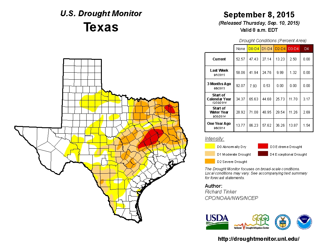 After 26 inches of heavy rain and flooding in May and June doused Central Texas and recharged the Edwards Aquifer, the landscape broke out in green, floral gratitude. Months later, with barely a trace of additional rain (less than a half-inch in July and August combined), and with heat indices breaking the 110-degree barrier, things are drying out again. By mid-August, much of Central Texas was already considered D0 (Abnormally Dry), with several areas entering D1 (Moderate Drought), according to the US Drought Monitor website. With the majority of Central Texas now in D1 and D2 (Severe Drought) status, the National Weather Service Climate Prediction Center forecasts drought conditions will persist or intensify as we move forward. In just the week from September 1 to 8, the percentage of our state experiencing drought (D0-D4) conditions rose by 5.5%.
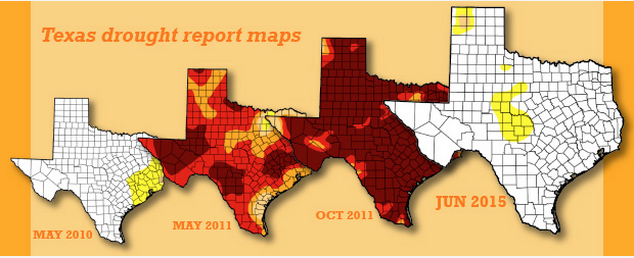
For those feeling a sense of déjà vu, we’ve definitely seen this pattern in Texas before. Drought cycles through our state, with at least one period occurring every decade in the 20th century. The Texas Development Board points out that we may be at the beginning stages of a similar trend to one we experienced from 2010-2011, as seen in this image from their article. The percentage of Texas experiencing Abnormally Dry or Drought conditions (D0-D4) in June of 2015 was relatively similar to May of 2010. If the past is repeating itself, we may be looking at an extremely dry time ahead. You can visit the US Drought Monitor to check conditions state and nationwide.
 This year’s historically-strong El Niño may play a role in breaking our dry spell, Mike Halpert, the deputy director of the Climate Prediction Center, told KXAN. The El Niño phenomenon occurs when warming Pacific waters result in above-average rainfall and below-average temperatures, especially in the Southern US (more info here). Then again, John Nielsen-Gammon, the Texas’ state climatologist points out that “the phenomenon can also be kind of a dud in Texas,” citing that “the two most intense El Niños did not produce the greatest amount of rain, and only increased rainfall totals by about 5 percent above normal” (Statesman).
If El Niño does throw some relief our way, we’ll all no doubt be grateful. Regardless, it’s never the wrong time to take action to conserve our most essential natural resource. Dry conditions in August have resulted in low inflows into the Highland Lakes, Buchanan and Travis. The amount of water in the two lakes combined dropped from 78% capacity, 1.56 million acre-feet, on August 1 to 75% capacity, 1.51 million acre-feet, on September 1 (LCRA). Not only do these lakes supply drinking water to more than a million people, they provide critical support to industries, businesses and agriculture along the lower Colorado River basin. We can all do our part to help slow depletion during drought. The EPA, as well as conservation-minded sites like Planetsave.com, provide tips for reducing your personal water use.
Here’s wishing you a cooler, wetter transition into Fall on September 23rd!
