No Drought
Lovelady well height: 533.89 ft-msl (119.53 ft-Depth to Water)
Barton Springs: approximately 111 cfs 10-day average
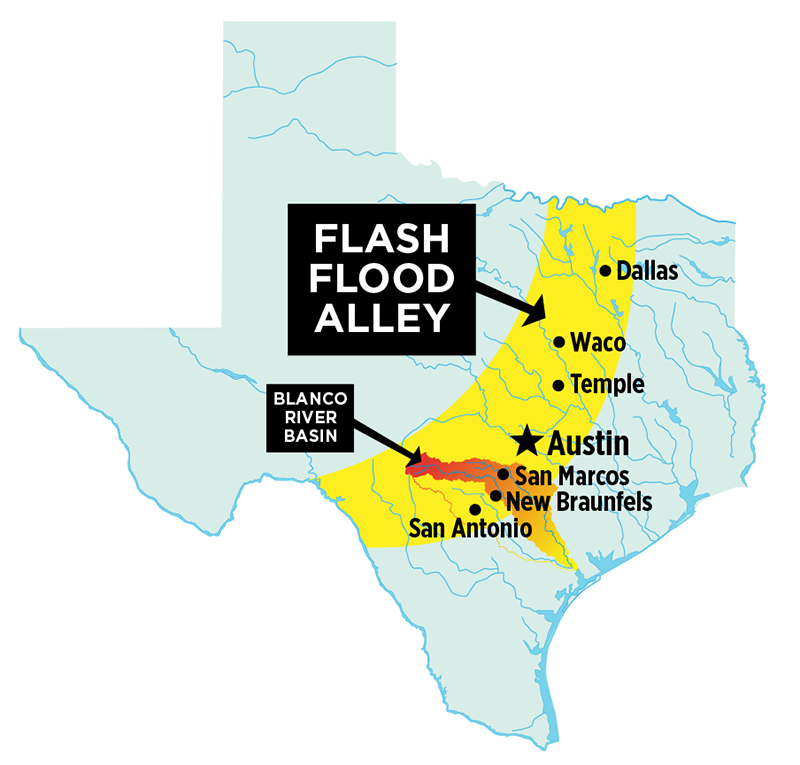
Central Texans are no strangers to floods, especially flash floods. In fact, according to the LCRA, the Hill Country and Central Texas region has even earned the nickname Flash Flood Alley due to a “greater risk of flash flooding than most regions of the United States.” In fact, according to the USGS, Texas has more than double the flood fatalities (since 1960) of any other state.
So what is the cause behind Flash Flood Alley? Floodsafety.com provdes a video graphic overview of the key factors that result in higher flash flood occurence across Central Texas. One key point is the region’s unique geographical location, often positioned at the meeting point of air masses converging from the Gulf and the Pacific. The resulting storms tend to generate high rainfall over short periods of time. When lots of rain falls in too short a time to allow for infiltration, flash floods are sure to follow.
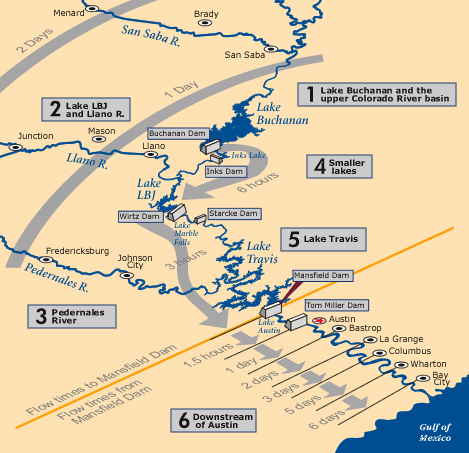 There are several dams in place, controlled by the LCRA, across the six Highland Lakes to help manage floodwaters from heavy rain in the region and prevent greater disasters in areas downstream. These are detailed in the graphic at left (LCRA), showing their progression toward the Gulf of Mexico. Hydrologists at the LCRA River Operations Control Center (ROCC) monitor these sites at all hours and manipulate the dam floodgates.
A year ago in May 2015, Wimberley and Houston experienced deadly floods. Last month, Houston had another. Brian K Sullivan of Bloomberg News explains that “Events like these are often called ‘100-year floods,’ but that can be misleading. The U.S. governments began using the term in the 1960s to describe a flood that has a 1 percent chance of happening in any given year, not a chance of happening only once a century.”
We should note that predictions of historic floods don’t necessarily account for other conditions that can alter the potential for an occurrence, for example climate change or an unusually strong El Niño or La Niña. “That’s why the 100-year event is such a moving target, especially in an urban environment,” said Chuck Watson, director of research and development at Enki Research, which develops tools to measure hazards. “Someone builds a couple of parking lots, and you just turned a 100-year event into a 70-year event because of the impervious surfaces… Asphalt doesn’t soak up rainwater; it just sends it somewhere else, such as into the house next door. When you add in natural climate cycles, the results are further skewed...One of the influences of El Niño is to send more rain across the southern U.S. In a situation like that, the chances of a catastrophic flood might rise to one in 20 according to Chuck Watson.” For more information on 100-year floods and how they’re defined, check out this article from the USGS.
With flooding common in periods of heavy rain, folks in Central Texas should live by these simple, but critical, rules to stay safer:
- Don’t drive over flooded roads or low water crossings; “turn around, don’t drown.” If you need to drive during rainy or flooded conditions, use ATXfloods.com for current updates to help you plan a route around dangerous areas
- If you find yourself stuck in a structure, or on high ground, during extreme flood conditions, do not try to swim for it. Stay where you are as long as possible to allow rescuers the opportunity to come to you
Take a look at this video, shared on Facebook by Robert Teague, of flash flooding in action. As you can see, a massive pulse of water is followed by a buildup of debris proceeding like a tiny monsoon over a low-water crossing. Needless to say, this type of flow is extremely dangerous.

