Tuesday, November 1, 2022

Aquifer District Declares Critical Drought (Stage III)


Aquifer District Declares Critical Drought (Stage III)


For Immediate Release: October 20, 2022

For more information, contact: David Marino, Communications & Outreach Manager at (512) 282-8441 or dmarino@bseacd.org


On October 20, 2022, Barton Springs/Edwards Aquifer Conservation District General Manager Tim Loftus, declared Critical Drought (Stage III). One of the District’s drought triggers, Lovelady Monitor Well, passed below its Critical Drought trigger on October 17, 2022. Only one of the District’s two drought stage triggers (Lovelady Monitor Well & Barton Springs) needs to be reached for a drought declaration to be made. However, to exit a drought stage, both Barton Springs and Lovelady must rise above their respective drought trigger values. This latter requirement keeps the District from making multiple declarations about drought over short periods of time.          


The District hasn’t been in Critical Drought (Stage III) since October of 2013. While drought conditions have improved across the state, central Texas still isn’t seeing much rain. So far, we have received below average rainfall every month this year except for February and August. May, June, and July of 2022 were the warmest on record for Austin. Reducing water use is now critical. With continued lack of rainfall and high rates of pumping, water levels could drop to the extent that some wells go dry. The District has already received reports of dry wells. Flow from Barton Springs could eventually decrease to the point where ecological, recreational, and aesthetic uses of Barton Springs would be damaged.


Declaration of Critical Drought (Stage III) requires all District permittees to implement mandatory measures specified in their User Drought Contingency Plans (UDCPs) to meet monthly pumpage reduction requirements:
  

·         30% for Edwards Historical and Conditional Class A permittees,

·         75% for Edwards Conditional Class B permittees, 

·         100% for Edwards Conditional Class C and Class D permittees, and

·         30% for Trinity and Alluvial/Austin Chalk Historical permittees


“We can’t afford to underestimate the threat that the current drought poses and the need for everyone to do their part to conserve water,” said General Manager Tim Loftus. 


End-user customers (60,000+ existing groundwater users in the District) served by water utilities on groundwater wells are required to comply with their utility’s water use restrictions for this drought stage. Generally, outdoor irrigation of lawns and landscaping is now prohibited or severely restricted. Groundwater uses should be limited for essential indoor demands needed to preserve health and safety with a very minor allocation provided for non-essential outdoor water use.


November is the first month that permittees will need to meet new reductions in pumpage. Permittees should refer to the monthly drought allocations listed in their User Drought Conservation Plan (UDCP) and Drought Target Charts.

Planting native or drought-tolerant landscapes, mulching, and using compost can substantially reduce the amount of irrigation water required to keep plants healthy. Making sure your irrigation system is functioning at peak efficiency and replacing leaking gaskets and hoses can help conserve water. Installing a rain barrel or rainwater harvesting system can make an even bigger impact in reducing overall water use.

The District recommends that both exempt and permitted well owners follow these conservation tips. For additional information on groundwater wells, please take a look at the District's Well Owner Guide. If you have questions about your well, please contact us at 512-282-8441. We encourage you to call or visit our office (1124 Regal Row, Austin, TX) during office hours (8 a.m. to 5 p.m.) to review our groundwater management process, receive information about the drought, or if you need assistance with other groundwater related matters.


Useful links:

·    Drought Management page:  http://bseacd.org/regulatory/drought-management/


Thursday, October 13, 2022

September 2022 Aquifer Update


The District remains in Alarm Drought (Stage II), which was officially declared at the June 9, 2022 Board meeting. However, the declaration of Critical Drought (Stage III) could happen by early to mid-October if we do not see additional rainfall. 


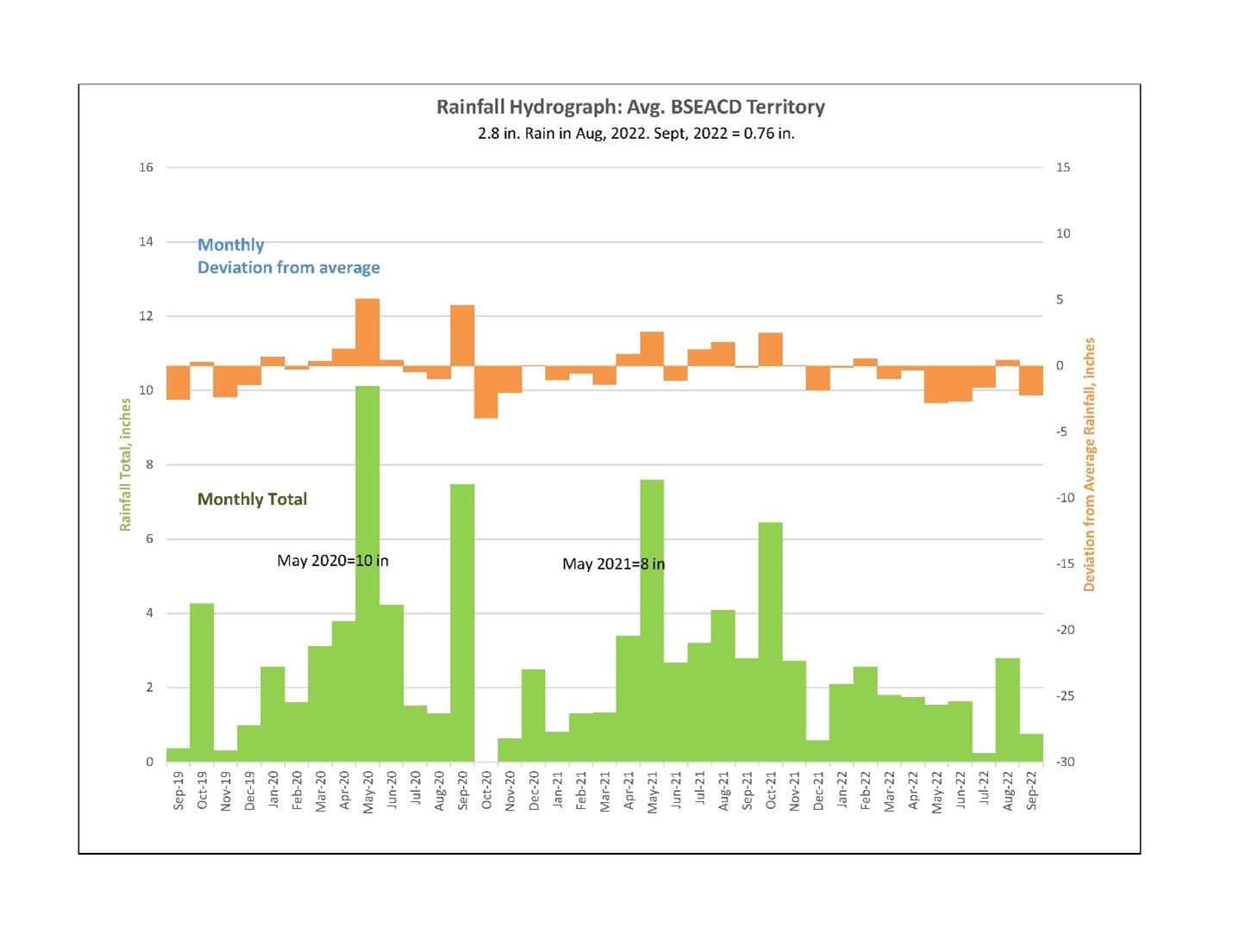
Despite widespread rains across Central Texas in August, a dry pattern quickly returned in September delivering only an average of 0.76 inches of rainfall between Travis and Hays counties. According to KXAN (Austin), rainfall recorded at Camp Mabry (0.47 inches) marks September 2022 as the 12th driest on record, while Austin-Bergstrom (0.14 inches) comes in as the 4th driest. This month isn’t supposed to be this dry. Typically, September is our 4th wettest month of the year, with almost 3.5 inches on average in Austin (KXAN). As of September 29 we’ve reached the 21st straight day without measurable rain. 

With no rainfall relief, drought conditions in the Texas Hill Country continue to worsen. We have received an average of 15.2 inches - 10.2 inches behind annual average rainfall - from January through September (figure 1). Edwards and Trinity aquifer levels began to decline in spring and continue to do so.

Figure 1. Monthly deviation from avg. and monthly total rainfall in BSEACD territory

Climate scientists forecast that La Niña conditions (declared by NOAA on October 14, 2021) are favored to continue into winter. The continuation of La Niña means that we are predicted to receive below average rainfall and above average heat through the summer and into the winter. It’s not until February 2023 that forecasters predict a chance of neutral conditions and increasing chances of returning Central Texas to average temperature and rainfall. 


May and June, which are historically the wettest months of the year in Central Texas, were both way below their historical monthly average (-2.8 & -2.7 respectively). Only August has provided above-average rainfall since February. May, June and July 2022 clocked in as the warmest on record for Austin. As a result, both aquifer levels and spring flows are approaching historic lows.

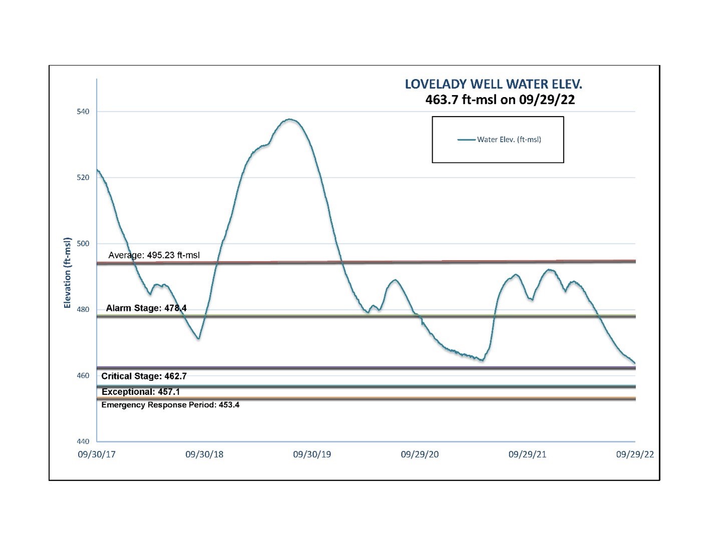
Lovelady crossed under the Alarm Drought (Stage II) trigger on May 26. On September 29, the well had a level of 463.7 ft msl, only 1 ft above Critical Drought (Stage III) (Figure 2). Without rain, it is expected to cross into Critical (Stage III) in early to mid-October. 

Figure 2. Lovelady monitoring well water elevation level

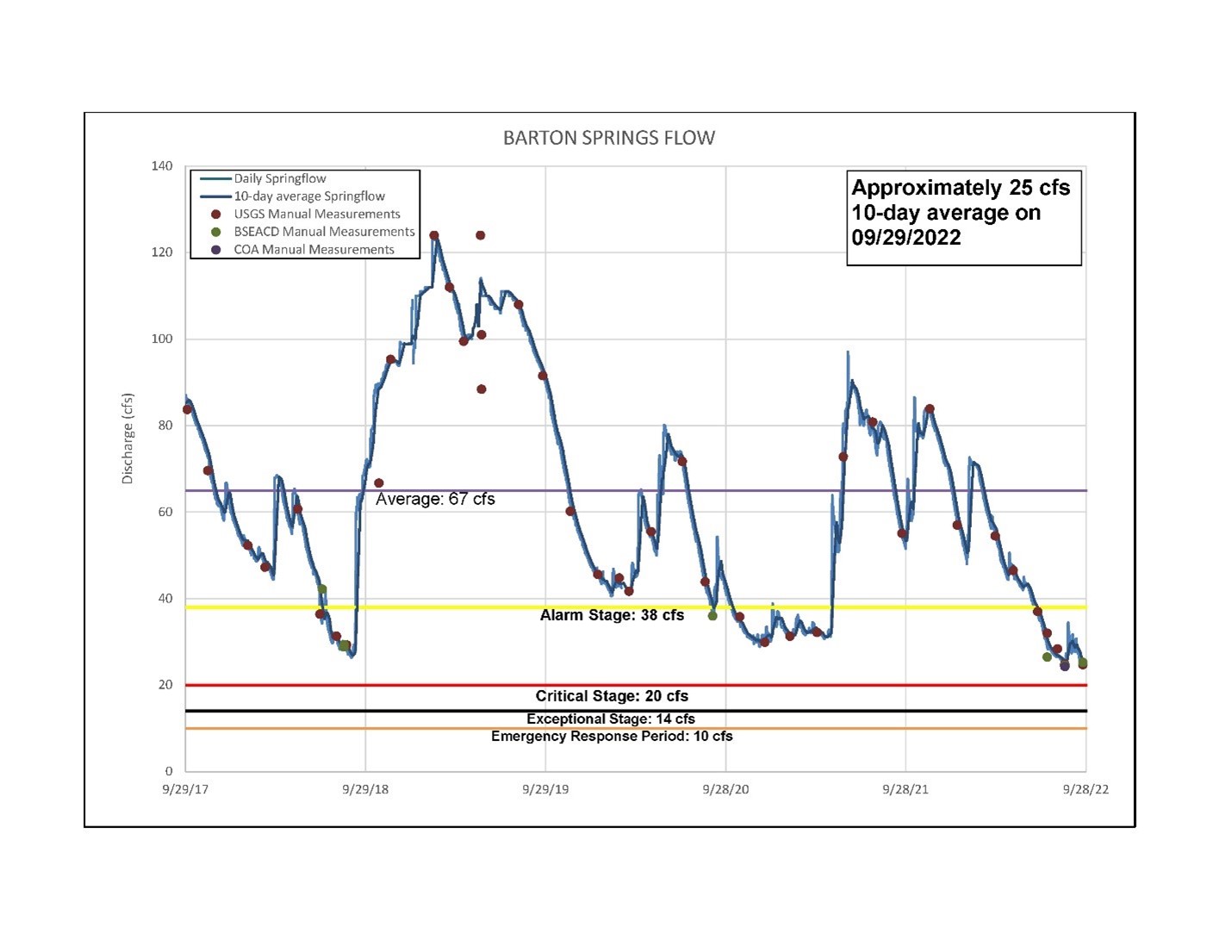
Also, Barton Springs crossed under the Alarm Drought (Stage II) trigger in late June. On September 29, Barton Springs was flowing at 25 cubic feet per second (cfs) (10-day average), 5 cfs above the Critical Drought (Stage III) trigger point of 20 cfs (Figure 3). Without rain, Barton Springs is also expected to cross into Critical Drought (Stage III) in early to mid-October. 

Figure 3. Barton Springs flow

The District could declare Critical Drought (Stage III) in the coming weeks if conditions continue to worsen.

Declaration of Critical Drought (Stage III) would require all District permittees to implement mandatory measures specified in their User Drought Contingency Plans (UDCPs) to meet monthly pumpage reduction requirements.  

  • 30% for Edwards Historical and Conditional Class A permittees,
  • 75% for Edwards Conditional Class B permittees, 
  • 100% for Edwards Conditional Class C and Class D permittees, and
  • 30% for Trinity and Alluvial/Austin Chalk Historical permittees

Again, the District could declare Critical Drought (Stage III) in the coming weeks. We will share that information on the District's social media channels, website, through our newsletter, and put out a press release when/if Critical Drought (Stage III) declaration happens.

Now is the time to brush up and double down on water conservation measures. Check out this great list of water saving tips from the Texas Water Development Board.

Generally, restricting outdoor water use, including limiting landscape irrigation, pool filling and refilling, and non-essential water use such as water fountains, are easy ways to conserve water. It's also best to only water your lawns once a week during the early morning hours. You can find more conservation tips for both indoor and outdoor conservation here.

The District recommends that both exempt and permitted well owners follow these conservation tips. For additional information on groundwater wells, please take a look at the District's Well Owner Guide. If you have questions about your well, please contact us at 512-282-8441. We encourage you to call or visit our office (1124 Regal Row, Austin, TX) during office hours (8 a.m. to 5 p.m.) to review our groundwater management process, receive information about the drought, or if you need assistance with other groundwater related matters.

Also, check out our drought information page. We will frequently update this page.

Other useful links:

Thursday, June 9, 2022

Aquifer District Declares Stage II Alarm Drought


Aquifer District Declares Stage II Alarm Drought


For Immediate Release: June 9, 2022
For more information, contact: David Marino, Communications & Outreach Manager at (512) 282-8441 or dmarino@bseacd.org

On June 9, 2022, the Barton Springs/Edwards Aquifer Conservation District’s Board of Directors declared Stage II Alarm Drought at its regular Board Meeting. The District’s drought triggers, Lovelady Monitor Well and Barton Springs, passed below their drought triggers in late May and early June respectively. Only one of the two drought stage triggers needs to be reached for a drought declaration to be made. However, to exit a drought stage, both Barton Springs and Lovelady must rise above their respective drought trigger values. This latter requirement keeps the District from making multiple declarations about drought over short periods of time.

The last groundwater drought declaration commenced on October 9, 2020, and ended on July 8, 2021. While the weather is getting warmer, strengthening La Niña (dry) conditions indicates it may be getting drier. So far, we have received below average rainfall every month this year except for February and above average heat. May 2022 was the warmest May on record for Austin. The average temperature in May was 82.3 degrees. That number was calculated by combining the high and low for each day.

Declaration of Stage II Alarm Drought requires all District permittees to implement mandatory measures specified in their User Drought Contingency Plans (UDCPs) to meet monthly pumpage reduction requirements.

  • 20% for Edwards Historical and Conditional Class A permittees,
  • 50% for Edwards Conditional Class B permittees,
  • 100% for Edwards Conditional Class C and Class D permittees, and
  • 20% for Trinity and Alluvial/Austin Chalk Historical permittees

End-user customers served by water utilities on groundwater wells are required to comply with their utility’s water use restrictions for this drought stage. Generally, restricting outdoor water use, including limiting landscape irrigation, pool filling and refilling, and non-essential water use such as water fountains, is sufficient to reach monthly pumpage targets for Stage II Alarm Drought. July is the first month that permittees will need to meet reductions in pumpage. Permittees should refer to the monthly drought allocations listed in their User Drought Conservation Plan (UDCP) and Drought Target Charts.

The District encourages continued conservation, with July and August often being the hottest and driest times of the year. In the summer months, outdoor water use is significantly higher and can account for 60% or more of home water use. Planting native or drought-tolerant landscapes, mulching, and using compost can substantially reduce the amount of irrigation water required to keep plants healthy.

Making sure your irrigation system is functioning at peak efficiency and replacing leaking gaskets and hoses can help conserve water. Installing a rain barrel or rainwater harvesting system can make an even bigger impact in reducing overall water use.

Useful links:

Tuesday, December 7, 2021

2021 Drought and Aquifer Status In Review

The year 2021 began with a status of Stage II Drought as below-average rainfall during the summer of 2020 wasn’t enough to keep levels from declining towards Stage II Drought thresholds. By early October 2020, Barton Springs and Lovelady crossed under their Stage II Drought thresholds and the BSEACD Board declared an Alarm Stage II Drought on October 8. Levels declined throughout the fall and winter as La Niña conditions - beginning in July 2020 - brought warmer and drier climate to the Hill Country leading into 2021.   

 Rainfall in 2021 began with a combined 3.5 inches of rain from January to March (3 inches below historical average), perpetuating the downward spring flow and water level trend. While some relief came with over 3 inches of rainfall in April, little recharge was seen as the dry soils soaked most of it up. The increased soil moisture from April rain set the stage for 8 inches of rain in May to generate enough recharge to reverse the downward spring flow and water level trends. The Climate Prediction Center (CPC) officially declared the end of La Niña in May 2021, beginning an ENSO-neutral (neither La Niña or El Niño) period that allowed for above average mid-spring and summer rainfall totals of 20.4 inches. Barton Springs and Lovelady water levels began to rise on May 1st for the first time since July 2020.  

 A combined 15 inches of spring rain fell March - June 2021, providing enough recharge to overcome the dry La Niña winter and reverse the falling spring flow and aquifer trend. With both Barton Springs and Lovelady water levels rising above their respective Alarm Stage II Drought thresholds, the BSEACD Board declared “No Drought conditions'' on July 8, 2021. An additional 7 inches fell in July and August. On August 25, Lovelady water levels began to decline, looking as if the No Drought period would be short-lived. The CPC officially declared the return of La Niña on October 14, 2021, which, oddly coincided with up to 6 inches of rainfall in the Hill Country the day before. This brought considerable recharge as stream gauges on all area creeks showed rises. Spring flow and water levels showed a rising response.   

 To summarize, the Austin/Hill Country area has received an average 36.4 inches of rainfall so far in 2021 (through December 7th), about 1 inch above the annual average, which means we will finish 2021with an above-average year. This may be due to the 6-month ENSO-Neutral period from March to October 14, 2021. While this might have allowed us to pass the 35.5 annual average, La Niña has officially developed again and is expected to continue into 2022. This could bring drier and milder-than-normal conditions across Central Texas, which will likely result in further declines as 2022 gets underway. Hopefully, spring of 2022 will bring its usual upward swing of recharge to keep the aquifers well-supplied.


Tuesday, October 26, 2021

Drought and Aquifer Status Update - Oct. 22, 2021

 The 2021 Central Texas summer has been noticeably mild, with temperatures in the Hill Country cooled by rainy and overcast days. This summer, Camp Mabry in Austin counted 31 days with measurable rain. That makes it the third rainiest summer when it comes to days of rainfall in the 123 years of record keeping. Between early June and Late September we received a rainfall total of 10.5 inches with July and August reporting above-average numbers.

While the above-average rainfall over the summer provided enough to keep vegetation on the surface nice and green, it wasn’t enough to generate substantial aquifer recharge to keep Edwards water levels at the Lovelady monitoring well from falling. Upper Trinity levels saw a substantial rise due to a combined 11 inches in April and May and have maintained elevated levels since. Middle Trinity levels have been declining since late June.

Aquifer levels in the Edwards and Middle Trinity continued to decline through a particularly dry September until heavy rain fell on September 9th. The heaviest amounts were seen in central Hays County, recording between 1 to 6 inches (texmesonet.org). The Austin area saw between 0.5 to 4 inches. Even this amount of rain didn’t generate much recharge because the very dry surface soils soaked up most of it. With increased soil moisture due to that rainfall, the stage was set for the next rain event to produce more runoff to recharge.

That rain came on October 13th as an average of 4.2 inches spread across the Hill Country. Some areas received up to 6 inches. This brought considerable recharge as stream gauges on all area creeks showed rises. This includes the Blanco River at Wimberley, where flow peaked at 11,400 cubic feet per second (cfs), Jacobs Well Spring & Cypress creek peaked at 361 cfs, Onion creek near Driftwood saw peak flow of 2,400 cfs and Barton Creek above Barton Springs reached 950 cfs just to name a few. Water levels as of October 19th in Edwards, Upper Trinity and Middle Trinity aquifers have seen a positive response to the rains (Figure 1). As of October 19th Lake Buchanan is 89% full and Lake Travis is 73% full.

Figure 1
Gray boxes show wet periods. Water-level data from three monitor wells.

So far in 2021 we have received a total of 33 inches of rain, just 2.5 inches below the annual average, which means we could finish 2021 with an above-average year. This may be due to a 6 month ENSO-neutral (neither La Nina or El Nino) period from March to October 14th. This neutral period has allowed for sufficient rainfall to bring us close to the 35.5 annual average.

According to the latest advisory from the Climate Prediction Center, La Nina officially developed on October 14th and is expected to continue into 2022. Remember that La Nina typically brings a warmer and drier climate to Central Texas. For more on La Nina visit here.

It was 10 years ago, in 2011, that climate experts blamed one of the worst droughts since the 7-year drought of the 1950s on the La Nina phenomenon. 2011 was the driest year ever for Texas with only 14.8 inches of rain.

Hopefully we can expect more rainfall before the end of the year even with the recently developed La Nina. As drought conditions always loom in Central Texas, it’s important that we continue our community effort to conserve water.

Wednesday, September 8, 2021

Potential La Nina Return for the 2021/22 Winter Season.

 The National Oceanic and Atmospheric Administration (NOAA) forecast a ~70% probability that La Nina will reemerge by early winter of 2021/21, which would be the second winter in a row. La Nina conditions in the southwestern US typically bring warmer temperatures and below-average rainfall. This feels discouraging as Central Texas groundwater levels have began to drop in late August.

The bright side is La Nina conditions in the the western US typically brings increased rainfall. This possible return of La Nina would be a welcomed change for our friends in the western US, who have endured terrible drought and the accompanying extreme heat and devastating wildfires.


Read more from NOAA's ENSO Blog here.

Thursday, July 8, 2021

Spring and Summer 2021 Aquifer Conditions and Drought Status


Since the beginning of 2021, the Hill Country - Edwards and Trinity Aquifer region has received a little over 18 inches of rainfall, providing some relief to the Stage II Alarm Drought (declared on October 8, 2020). Consistent small rain events in March and April raised soil-moisture content (amount of water present in the soil), priming the area for runoff conditions. Ten inches received in May and June - usually the two wettest months of the year - produced above-average rainfall, generating plenty of runoff to area creeks and much needed aquifer recharge. On May 1st 2021 Lovelady, the District’s drought index well, began to rise for the first time since July 2020.


Figure 1.


In response to the May-June rainfall, aquifer level at the Lovelady monitor well and springflow at Barton Springs have both risen above Alarm Stage II drought triggers (Figure 1). Lake Travis water levels have also seen an increase of about 7 feet since January 2021. The BSEACD weather station has reported 2.7 inches in June and 1.3 inches so far in July, about 0.7 inches below the month’s historical average, but rain chances persist in July. 


Happily, the majority of Texas is out of meteorological drought status, with only a few areas in West Texas demonstrating “abnormally dry” to “severe drought” conditions (Figure 2). For updated information on the drought status throughout Texas, refer to the United States Drought Monitor.


Figure 2


With both Barton Springs and the Lovelady water level currently above their respective Alarm Stage 2 drought triggers the BSEACD Board declared “No Drought” conditions at the July 8, 2021 board meeting. For the District to declare drought conditions, either Lovelady water levels or Barton Springs flow need to be below their respective drought thresholds. However, to exit a drought stage, both spring flow and water level must rise above their respective drought trigger values. This latter requirement keeps the District from making multiple declarations about drought over short periods of time.


The spring and early summer rains have helped lift us out of drought. However, July and August are historically very hot and dry months, and without additional rainfall this wet trend may reverse resulting in drops in springflow and aquifer levels. Figure 3 shows 2020 Lovelady water level trends juxtaposed to 2021 trends. The green line indicates 2020 water levels significantly increasing due to March-May rainfall, then declining back into drought within 77 days of the dry summer season. 2021 currently demonstrates the same pattern, with a much more dramatic increase during the rainy months. With the clear correlations moving through the spring, we might predict a similar decline through summer 2021 without additional rain.


Figure 3


According to an unknown state meteorologist from Texas in 1927, “Texas is a land of perennial drought broken by the occasional devastating flood. “We see this statement ring true as 2021 rolls into summer. For now, we exit drought status. Drought will always be a concern for our beloved home state, so let’s maintain our dedication to conserving our most precious natural resource. 

Monday, April 5, 2021

World Geologist Recognition Day!

 Stage II Alarm Drought

Lovelady Well Height: 465 ft-msl

Barton Springs: approximately 33 cfs 10-day average


Geologists Day is celebrated annually on the first Sunday of April throughout the world. It was established by a group of well-known Soviet geologists in April 1966. A geologist is a scientist who studies the Earth’s physical structure and substances, the history of rocks, the processes that act on them, as well as the organisms that inhabit the earth. They work to understand the history of the planet we live on, to better predict the future and explain current occurrences. Geologists are involved in the discovery of resources that are used in all aspects of our daily lives.

There are many types of geologists, including hydrogeologists. Hydrogeology deals with how water gets into the ground (recharge), how it flows in the subsurface (through aquifers) and how groundwater interacts with the surrounding soil and rock (the geology). The District wants to recognize Brian Smith, Principal Hydrogeologist, Justin Camp, Hydrogeologist Technician, and Jeff Watson, Staff Hydrogeologist for their contributions and hard work in the world of hydrogeology.

 Happy Geologists Day!

https://www.youtube.com/watch?v=AqeQGGPkNMw


Friday, February 12, 2021

Jacobs Well Monitoring


 As La Nina conditions persist - bringing warmer and drier climate to Central Texas - so do drought conditions in the Edwards and Trinity aquifers. This includes the Trinity fed Jacobs Well Spring (JWS) in Wimberley. Flow reported at the JWS gauge nears 0.0 cubic feet per second (cfs). JWS serves as a drought stage indicator for the Hays Trinity Groundwater Conservation District (HTGCD) within the Jacobs Well Groundwater Management Zone.

For HTGCD to protect groundwater supplies and JWS flow they have been busy coordinating with the U.S. Geological Survey (USGS) and the Edwards Aquifer Authority (EAA) to ensure that the data reporting at the JWS gauge are as accurate as possible. For more info on Jacobs Well monitoring visit here.

Wednesday, December 9, 2020

2020 Aquifer Status In Review

Stage II Alram Drought

Lovelady Well Height: 469 ft-msl

Barton Springs: approximately 30 cfs 10-day average


Year 2020 began with a status of No Drought due to a very wet 2018, but below-average rainfall in 2019 caused water levels and spring flow to enter a downward trend beginning in late July. The declining trend continued with below-average rainfall up to 2020. The new year started out very wet with a combined 11 inches of rain from January to April (3 inches above historical average) reversing the downward trend and avoiding crossing drought thresholds in mid-March. A total of 35 inches of rain as of mid-December 2020 has provided much needed recharge to the Edwards and Trinity Aquifers, but not enough to reverse the downward trend. On October 8, 2020, the Board declared Stage II Alarm Drought.

 To look back in more detail, a combined 14 inches of spring rain fell in May and June 2020 providing even more recharge to that provided in January through April. Barton Springs flow quickly responded to these rains, propelling spring flow further away from drought triggers. The below-average rainfall in the fall of 2019 and additional spring 2020 rains maintained an average daily spring flow of 58 cfs throughout 2020.

The wet spring only temporarily held off drought as summer came with a drying trend that brought water levels and spring flow back into decline beginning in early July. September provided 7 more inches of rain but did little to reverse the downward trend. This decrease has continued through a dry fall season and on October 8, 2020, the Board declared Stage II Alarm Drought. The last groundwater drought declaration commenced on July 12, 2018 and ended on October 11, 2018. This dry period is projected through the winter and into spring 2021, as we enter a La Nina year bringing drier and warmer conditions to the southern United States.

To summarize, the Austin/Hill Country area has received an average 36 inches of rainfall so far in 2020, producing recharge for local aquifers. However, below-average rainfall in 2019 and a relatively dry summer and fall 2020 hasn’t provided enough recharge to stay above Stage II Alarm Drought. Official forecasts point toward the La Nina effect bringing drier and milder-than-normal conditions across Central Texas, which will likely result in further declines as 2021 gets underway. Hopefully, spring of 2021 will bring its usual upward swing of recharge to keep the aquifers well-supplied.


Tuesday, October 13, 2020

La Nina in the Tropical Pacific and its Implications on Central Texas


Stage II Alram Drought

Lovelady Well Height: 476 ft-msl

Barton Springs: approximately 38 cfs 10-day average

 In September 2020 the National Oceanic Atmospheric Association (NOAA) issued a La Nina advisory suggesting that there's a 75% chance it hangs around through the winter. Come this October an increased 85% chance it lasts through winter and into spring 2021.

So what is La Nina? What does it mean for weather and rain in Central Texas?

La Nina is the opposite of El Nino, a cooling of the equatorial east-central Pacific Ocean. The strength of the 2020 La Nina (weak, moderate or strong) will determine what impacts it may have on the weather this winter to next spring 2021. Typically, the southern tier of the U.S. sees drier than average conditions and temperatures that are above average, while much of the Pacific Northwest and the Ohio Valley are wetter than normal and see below average temperatures. (Weather Channel)


As of October 8th the Edwards and Trinity aquifers are in Alarm Stage II Drought. Due to a lack of rain and recharge in 2020 and the ensuing La Nina leading into 2021 it is paramount that we practice proper conservation techniques. For more info on the La Nina outlook visit: https://www.climate.gov/news-features/department/enso-blog

Monday, October 12, 2020

BSEACD Board Declares Stage II Alarm Drought on 10/8/20

Stage II Alarm Drought

Lovelady Well Height: 476 ft-msl

Barton Springs: approximately 38 cfs 10-day avg


For Immediate Release: Friday, October 9, 2020

For more information, contact: Vanessa Escobar, General Manager at (512) 282-8441 or 

vescobar@bseacd.org


On  October  8,  2020,  the  Barton  Springs/Edwards  Aquifer  Conservation  District’s  Board  of 

Directors declared Stage II Alarm Drought at its regular Board Meeting. The District Lovelady 

Monitor Well passed below it’s respective drought trigger in late September. Only one of the two 

drought  stage  triggers  needs  to  be  reached  for  a  drought  declaration  to  be  made.  The  

District acknowledges  that  indoor  use  may  be heightened  in  some  cases  due  to  COVID-19  

responses, however it is still a shared duty to reduce all non-essential water use during drought.


The last groundwater drought declaration commenced on July 12, 2018 and ended on October 11, 2018. 

Recharge in late 2018 and early 2019 associated with above-average rainfall helped maintain water 

levels in area aquifers until recently. Since July of 2019, both flow at Barton Springs and the 

water level at the Lovelady monitor well have been declining. As of early April 2020, both have 

been hovering near trigger levels. Recent rainfall has not generated enough runoff to sustain creek 

flow in the creeks and rivers that recharge the aquifers.


Declaration of Stage II Alarm Drought requires all District permittees to implement mandatory 

measures specified in their User Drought Contingency Plans (UDCPs) to meet monthly pumpage 

reduction requirements.

•     20% for Edwards Historical and Conditional Class A permittees,

•     50% for Edwards Conditional Class B permittees,

•     100% for Edwards Conditional Class C and Class D permittees, and

•     20% for Trinity and Alluvial/Austin Chalk Historical permittees

End-user customers served by water utilities on groundwater wells are required to comply with their 

utility’s water use restrictions for this drought stage. Generally, restricting outdoor water use, 

including limiting landscape irrigation, pool filling and refilling, and non-essential water use 

such as water fountains, is sufficient to reach monthly pumpage targets for Stage II Alarm Drought. 

November is the first month that permittees will need to meet reductions in pumpage. Permittees 

should refer to the monthly drought  allocations listed in their  User Drought  Conservation Plan 

(UDCP) and Drought Target Charts.


Useful links:

•     Drought Media Tool-Kit: https://bseacd.org/drought-edu/

•     Press Release archive:  http://bseacd.org/publications/press-releases/

•     Drought Status page:  http://bseacd.org/aquifer-science/drought-status/

•     Drought Management page:  http://bseacd.org/regulatory/drought-management/


Monday, September 21, 2020

Texas Needs to Prepare for a 'Megadrought,' State Climatologist Warns

 No Drought

Lovelady Well Height: 478.5 ft-msl

Barton Springs: approximately 48 cfs 10-day avg

Texas is no stranger to droughts. From the bone-dry stretch of the 1950s, the state’s longest drought, to the fiery months of 2011, the state’s single driest year, droughts have shaped Texas' culture and economy.

But, according to the state climatologist of Texas, John Nielson-Gammon, we ain’t seen nothing yet.

Read full KUT 90.5 article here:

https://www.kut.org/post/texas-needs-prepare-megadrought-state-climatologist-warns


Tuesday, August 25, 2020

CITY OF BUDA DECLARES STAGE 1 WATER RESTRICTIONS Effective Monday, August 24, 2020

Aug. 20, 2020 - Effective Monday, Aug. 24, 2020, Stage 1 Water Restrictions will go into effect for City of Buda water customers in accordance with the City’s adopted Water Resource Management and Drought Response Ordinance. This is due to the lack of consistent precipitation, and higher than normal demands on our water production system. Under Stage 1, twice per week mandatory watering restrictions are now in place. Violation of the ordinance could result in a fine of up to $2,000 per offense and a surcharge on the customer’s utility bill. For more on Stage 1 restrictions and water conservation tips visit: https://www.ci.buda.tx.us/232/Water-Conservation


Official City of Buda website post: https://www.ci.buda.tx.us/CivicAlerts.aspx?AID=1153

Monday, August 10, 2020

Hays Trinity GCD Declares Drought for Jacob's Well Groundwater Management Zone

Flow at Jacob's Well has dropped below the drought threshold triggering a drought declaration by the Hyas Trinity Groundwater Conservation District at the August 6 Board Meeting. With the Jacob's Well Groundwater Management Zone (GMZ) drought declaration, permittees operating wells within the GMZ are required to reduce pumpage by 20% to extend diminished groundwater supplies. - Wimberley Valley Watershed Association.

Read more here.

 Drought Stage


Note: The Jacob's Well GMZ is in the Hays Trinity GCD boundary and not in the Barton Springs Edwards Aquifer Conservations District boundary.

When It Rains, Texans Forget Drought and Worsening Water Scarcity

 Article by Keith Schneider, Circle of Blue

August 3, 2020

After the Pandemic, soaring population growth, development will again challenge planning and water Supply in the Texas Hill Country.

Monday, August 3, 2020

Tropical Storm Hanna, a Record-Breaking Tropical Storm Season and a Coin-Flip La Nina for the Fall

Summary:
  • The amount of the state under drought conditions increased from about 25 percent four weeks ago to about 36 percent
  • Despite drought conditions, statewide reservoir storage is normal for this time of year
  • Tropical Storm Hanna should improve drought conditions in Central and South-Central Texas
Read full article here


Aquifer Monitoring Tools

No Drought
Lovelady well height: 487 ft-msl
Barton Springs: approximately 61 cfs 10-day avg

Aquifer conditions are dynamic, with water levels often fluctuating 

due to drought, recharge, and pumping. The use of monitor wells 

with specialized equipment helps track these changes in order to 

inform policy that protects water supplies and spring flow for all users. 

After all, groundwater is a shared resource.


We’re often asked the question: 

“How are aquifer conditions determined?” o

“How are aquifers monitored?” 

The short answer: "Monitor wells!" 

You can view the District (and other agency) 

monitor wells and aquifer data HERE.


BSEACD staff employ several types of equipment to collect 

continuous, accurate measurements and observe aquifer 

trends at a number of area monitor wells and for various 

aquifers. Equipment and techniques vary from manual 

periodic measurements with an electric tape, to automated 

sensors that record and store measurements over time.


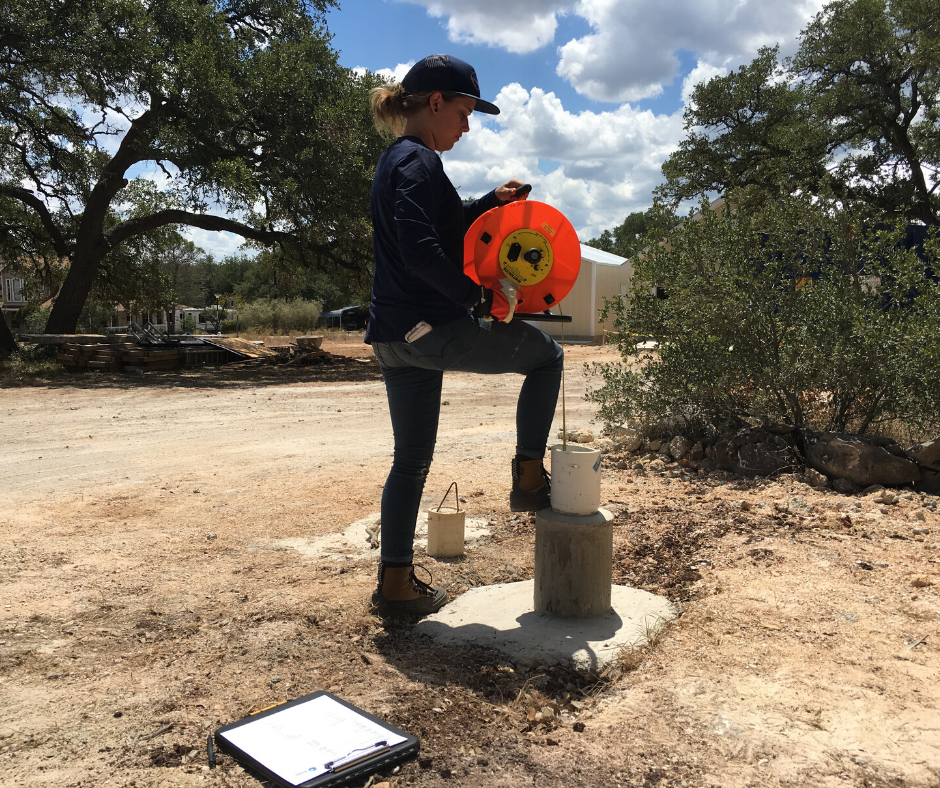
Many well owners have seen BSEACD staff visit their wells 

to take a manual water-level reading using an e-line. 

A manual measurement is a reliable and accurate method 

to measure water levels in a well and is often used to verify 

automated sensor accuracy. However, a manual measurement 

only represents a snapshot of a well's water level for a given 

date and hydrlogic condition and is time-consuming.

While all monitor wells have manual measurements, wells 

that are only manually measured periodically are called ‘periodic’ 

monitor wells, meaning staff will make a visit one to two 

times a year to get a snapshot measurement.


The most common technique the BSEACD uses to collect 

continuous water levels is equipping monitor wells with a 

pressure transducer probe. The probes measure the 

water pressure above the instrument as it changes and r

ecords the corresponding water level every hour. 

Staff stop by these transducer wells quarterly to 

download the data, or more frequently to aid with scientific studies.


While many continuous monitoring sites are active domestic wells, 

monitoring does not interfere with operation of the well. 

These monitor wells are often plumbed with a small PVC pipe that 

keeps the pressure transducer and cable away from the pump wires 

and the pipe that brings water to the surface.


The newest type of monitoring technology being used for water-level

measurements is a sonic (sound) sensor. This sonic sensor records

the depth to water from the top of the well to the water level using

sound pulses. The data is recorded in real-time and is transmitted via

WiFi to a cloud-based platform which processes and archives the data.

Data can be retrieved at any time with an internet connection.

Staff have deployed seven sonic sensors on Edwards and Trinity

wells in the last two years. One major advantage of this system

is the ability to display water-level readings in real-time through

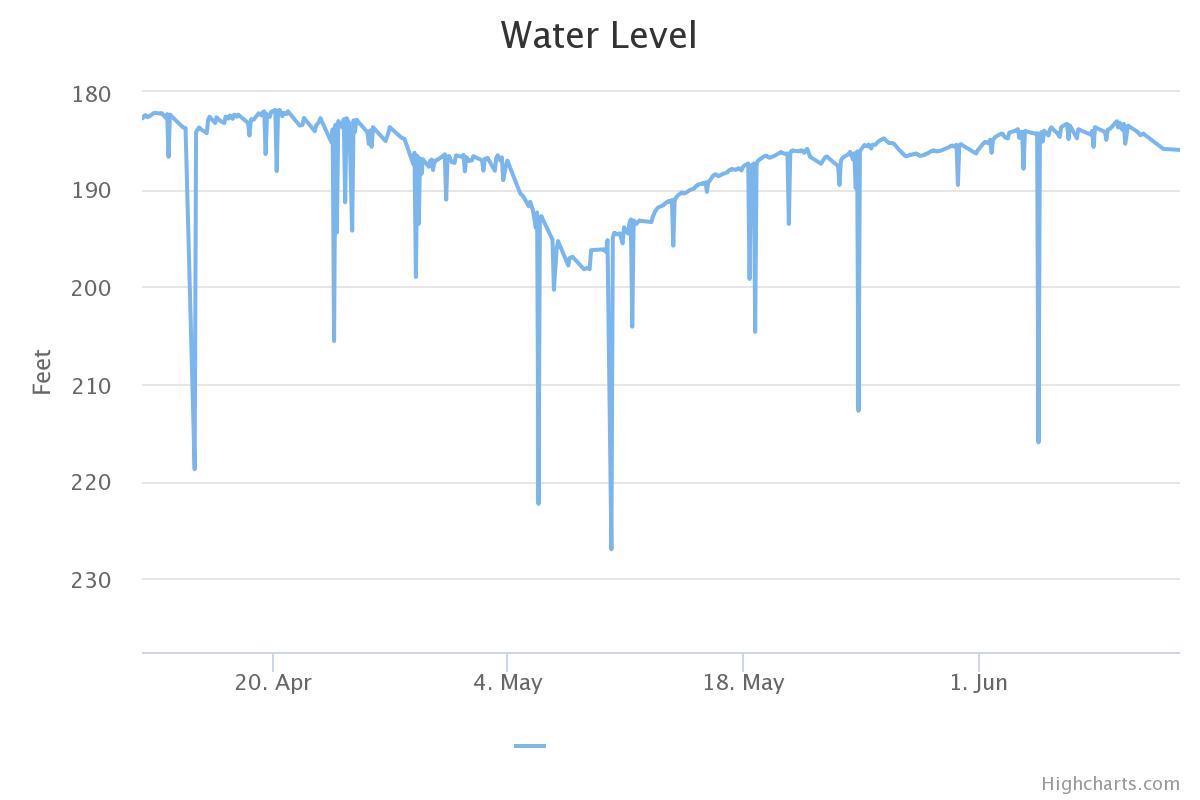
the online dashboard (as seen in the hydrograph below) which helps

to analyze trends over time.


An additional benefit is that the sensor can detect when the pump is 

active and can label the data it collects as under the influence 

of the pump. Several other groundwater entities are now deploying 

these units, including Edwards Aquifer Authority, Comal Trinity GCD, 

and Hays Trinity GCD. This is providing a larger network of real-time 

monitoring.


Water levels are the most basic information one can collect about

groundwater resources. Understanding how water levels are changing

over time in individual wells, and across an aquifer, can tell us a lot

about drought conditions and the increasing demand on groundwater

resources. Therefore, collecting accurate, long-term, frequent, real-time

water-level data is critical to having a science-based approach to 

conservation and management of our most precious shared resource.